

Former Typhoon Merbok to blast western Alaska with historic storm surge, 90 mph wind and 50-foot seas

ADAK, Alaska - A historic storm is bringing hurricane-force winds, 40-50-foot seas and coastal flooding not seen in decades to parts of western Alaska on Friday and Saturday.
What used to be Typhoon Merbok has morphed into a powerful northern Pacific storm as it races nearly due north and pushes through the Aleutian Islands and into the Bering Sea, bringing a dangerous storm surge that threatens to inundate coastal villages and towns under several feet of water for hours.
"Even though it is not officially a typhoon – which is what we could call a hurricane in the (U.S.) – it still has all of that powerful energy," said FOX Weather meteorologist Britta Merwin.
As the powerful storm's fierce winds push the sea ahead, storm surge will rival that of typical hurricane impacts. A surge of 8-11 feet is expected in Nome starting late Friday, with 9-13 feet of surge expected near Golovin and 12-18 feet of surge along the coast from Elim to Koyuk. The highest waters are expected Saturday.
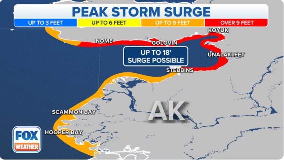
Alaska Storm Surge Forecast(FOX Weather)
"With strong winds, you’re pushing in a lot of water, and that means the sea levels (are) going to rise and coastal flooding is a concern as well as storm surge," Merwin said.
ALASKA EXPERIENCES AN EARTHQUAKE EVERY 10 MINUTES, SCIENTISTS SAY
What's worse, high water levels will continue for 10 to 14 hours, allowing wind-driven waves on top of the surge to push far inland and produce additional damage.
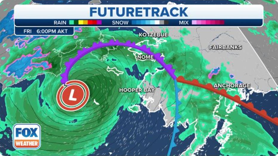
Alaska Storm Setup(FOX Weather)
"Impacts may exceed the 2011 Bering Sea Superstorm, and some locations may experience their worst coastal flooding in nearly 50 years," National Weather Service forecasters in Fairbanks wrote early Friday morning.
Meanwhile, wind gusts are expected to reach 75-90 mph in some areas along the Aleutians on Friday and the southern and western coasts along the Bering Sea Saturday with the strongest core of winds forecast between Adak and Shemya. Storm-force winds of 55-73 mph are expected 500-800 miles around the low-pressure center.
"The storm is massive," Merwin said. "It’s still holding on to all those characteristics from when it was a typhoon, but now it’s a cold-core system – a non-tropical storm – that’s going to blast Alaska with some very strong winds."
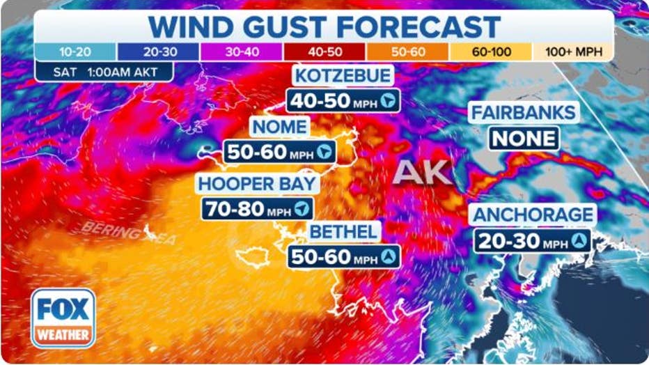
Alaska Predicted Wind Gusts (FOX Weather)
Already Friday morning, a buoy south of Amchitka Island in the western Aleutians recorded 41-foot waves as the town of Adak registered multiple gusts to 75 mph.
Intense storm systems are common for Alaska, but seeing an extra-tropical cyclone with a pressure of about 940 millibars is not frequent.
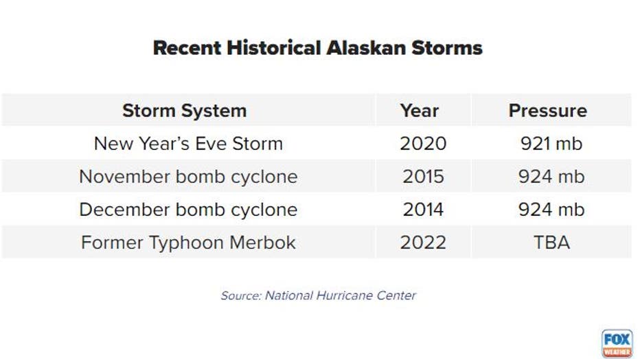
"It’s definitely going to be a significant event. It’s shaping up to be one of the worst events that we’ve seen for years," the National Weather Service office in Fairbanks, Alaska, said.
Threatened region contributes $5 billion to Alaska's economy
Communities such as Adak, Unalaska, St. Paul, St. Johns and Bethel will all be near the center of the storm, where winds and rains will be the heaviest.
"For most of those Alaskan communities, when a storm is bearing down, they don’t have the capability for evacuations. So, what they normally do is they’ll go to a community shelter, which is the safe option," said Jeremy Zidek, public information officer at Alaska’s Division of Homeland Security and Emergency Management. "Supply chain issues, transportation issues and weather issues are kind of a regular occurrence, so people have to be pretty resilient to even live in those areas."
Several alerts that include a Coastal Flood Watch, Storm Warning and Gale Warning have been issued by the NWS ahead of the arrival of the worst of the weather.
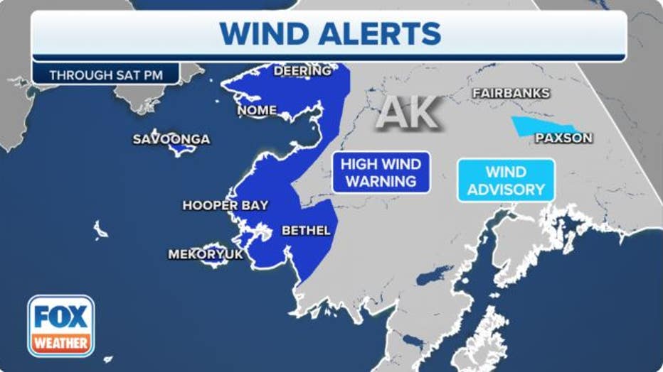
Alaska Wind Alerts(FOX Weather)
FAA ADDING WEATHER STATIONS ACROSS ALASKA TO INCREASE AVIATION SAFETY
Meteorologists and first responders are most concerned about the maritime community, which produces most of the nation’s seafood.
Pacific salmon, crab, Pacific cod, shrimp, herring, sablefish pollock, and Pacific halibut are all harvested from Alaska and lead to more than $5 billion in economic activity in Alaska every year.
Fomer Typhoon Merbok to have affect on U.S. weather
Typhoon Merbok is one of several significant storm systems from the West Pacific that are expected to get caught up in the jet stream and impact U.S. weather.
Abnormally warm water in the North Pacific is one of the ingredients helping to enhance the lifecycle and strength of the northern cyclones but not enough to help them sustain their tropical cyclone identity into the northern latitudes.
Similar to the Atlantic basin, the Northwest Pacific typhoon season is running behind normal, only seeing about half the storms that they are used to seeing by mid-September.
During recent weeks, the West Pacific has seen an uptick in activity with typhoons Muifa, Hinnamnor and Merbok.
Most, if not all, will lead to impacts in Alaska with rain, wind and high seas, meaning that the 49th state might be in store for a rainy time period.
Experts with the NWS’ Climate Prediction Center expect several weeks of above-average rainfall in the state.
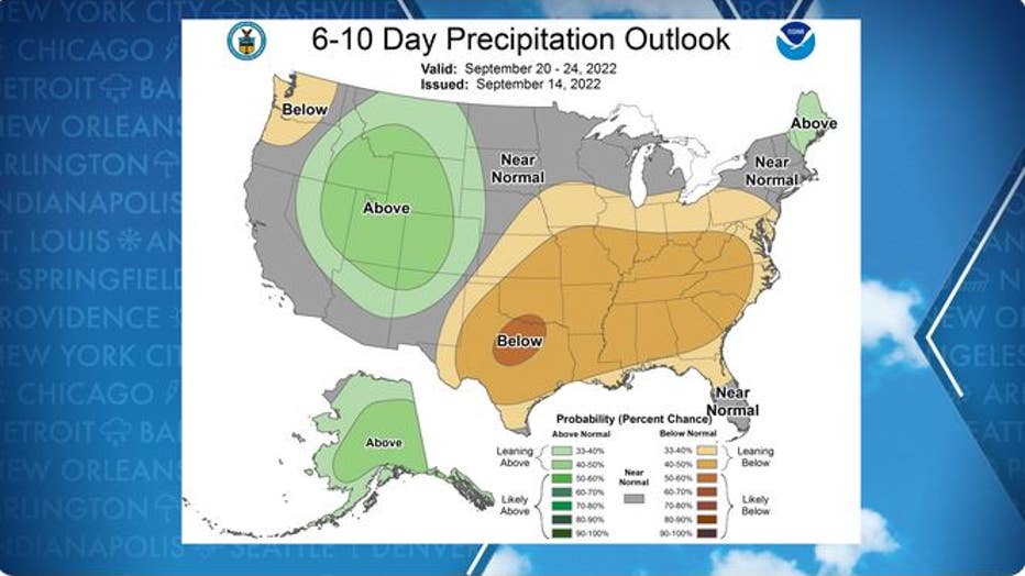
Forecasters believe there will be increased rainfall chances across Alaska during the next several days.
Get updates to this story on FOXWeather.com.