

Another day of severe weather brings tornado threat to Central Florida

Severe weather brings tornado threat to Central Florida
Thursday was the latest in a multiday severe weather threat that brought heavy rain and damaging wind to parts of Central Florida. Several tornado warnings were issued late afternoon and into the early hours with reports of downed trees and power outages.
ORLANDO, Fla. - Thursday was the latest in a multiday severe weather threat that brought heavy rain and damaging wind to parts of Central Florida. Several tornado warnings were issued late afternoon and into the early hours with reports of downed trees and power outages.
The storms bubbled up earlier in the day across the Florida Panhandle. As the system pushed into the eastern part of the state, the weather caused SpaceX to scrub a planned Falcon Heavy launch of a satellite from Cape Canaveral. NASA encouraged visitors and employees to seek shelter until the severe weather moved offshore. The launchpad was reportedly struck by lightning.
"They're going to have to do a thorough evaluation of the pad and the rocket and the satellite and all the systems to make sure nothing was damaged at the pad and even near the pad," said Dr. Ken Kremer of Space UpClose.
In nearby Titusville, there were reports of heavy rain and flooding. While there were at least two tornado warnings issued in Brevard County on Thursday, FOX 35 News crews did not observe any significant damage.
At the peak of Thursday's utility outages, it was estimated that about 18,000 homes were without power.
Watch FOX 35 News for latest headlines
Help tell the weather story: Send your weather photos and videos to FOX35Tips@FOX.com. Your safety is most important. Please only record photos or videos if and when safe.
Below is an account of the day's weather events:
FOX 35 Storm Team weather updates
11:05 p.m. - A tree has fallen on top of an Orlando Police Department cruiser in Downtown Orlando on Washington St.

Storm topples tree onto Orlando Police car
A tree has fallen on top of an Orlando Police Department cruiser in Downtown Orlando on Washington St.
9:21 p.m. - A Severe Thunderstorm Warning has been issued for Sumter County until 9:45 PM. At 920 PM EDT, severe thunderstorms were located along a line extending from 6 miles south of Inverness Airport to near Wesley Chapel South, moving east at 40 mph.
9:10 p.m. - A wall of storms is pushing quickly to the east into Central Florida.
8:58 p.m. - A Severe Thunderstorm Warning has been issued for Alachua and Marion counties until 9:45 PM.
8:25 p.m. - A Tornado Warning for Orange and Osceola counties has expired.
8:06 p.m. - A Tornado Warning has been issued for southeastern Orange and northeastern Osceola counties in effect until 8:30 PM. At 8:03 PM, a severe thunderstorm capable of producing a tornado was located 9 miles east of Narcoossee, moving east at 20 mph.
7:48 p.m. - Tornado Warning for Brevard County has been canceled.
7:35 p.m. - What should you do when a tornado threat looms? Acting quickly is key to staying safe and minimizing impacts. Follow these tips from the National Weather Service. Be sure to download the FOX 35 Storm Team Weather App to track storms with the interactive live radar and receive any watches or warnings.
7:30 p.m. - A Severe Thunderstorm Warning has been issued for Osceola until 8 PM. At 7:29 PM, a severe thunderstorm was located over Kenansville and moving northeast at 30 mph. Hazards include 60 mph wind gusts and quarter-size hail.
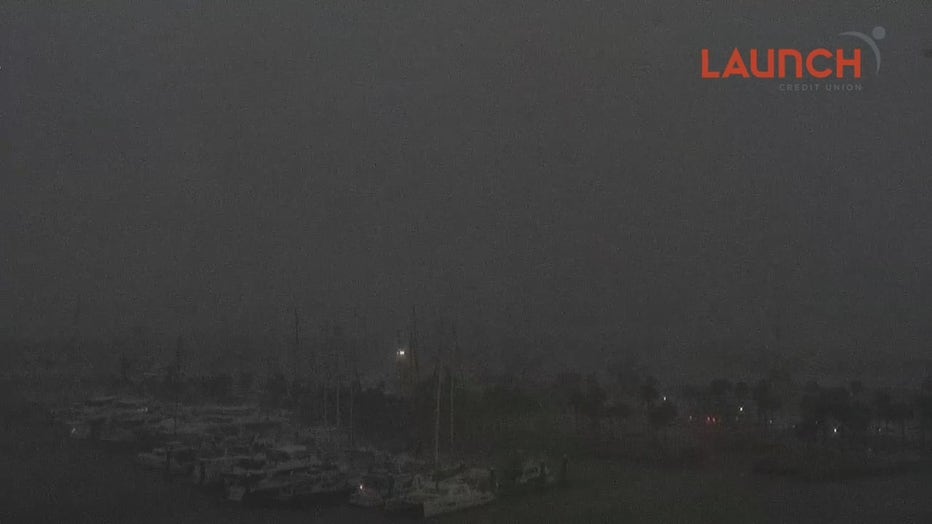
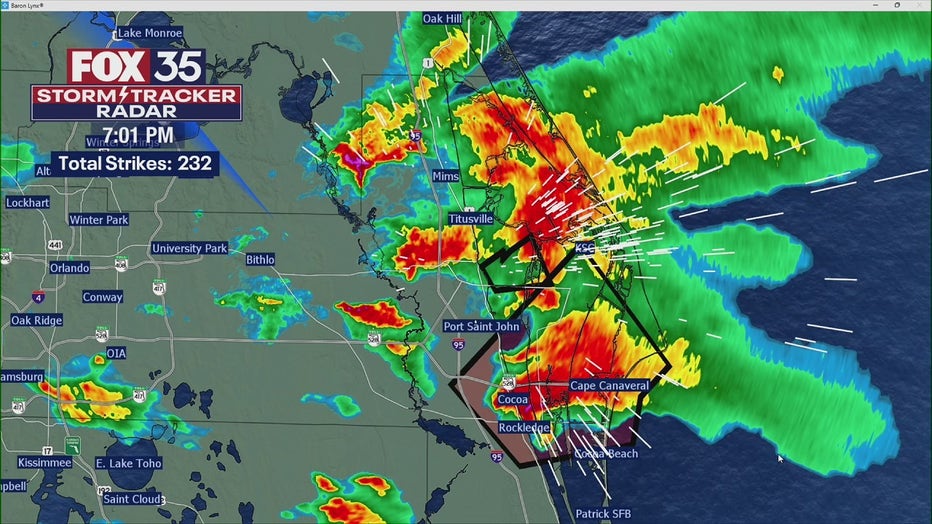
7:22 p.m. - Tornado Warning has been extended for Brevard County until 8 PM. At 7:17 PM, a severe thunderstorm capable of producing a tornado was located near Playalinda Beach, moving east at 20 mph. Below is the view from our Launch Credit Union Port Canaveral camera. You can this camera and other FOX 35 live weather cameras here.
6:57 p.m. - Tornado Warning extended for Brevard County until 7:30 PM. At 656 PM EDT, a severe thunderstorm capable of producing a tornado was located over Rockledge, moving northeast at 15 mph.
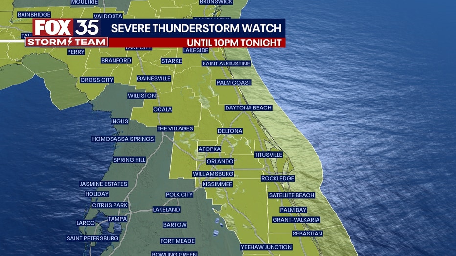
6:51 p.m. - The Tornado Warning for southeastern Seminole and south central Volusia counties has been canceled. The storm which prompted the warning has weakened below severe limits and no longer appears capable of producing a tornado. A Severe Thunderstorm Watch remains in effect until 10 PM for East Central Florida.
6:47 p.m. - Tornado Warning extended for Brevard County until 7:15 PM. At 6:40 PM, a severe thunderstorm capable of producing a tornado was located near the Titusville Airport, and is nearly stationary.
6:27 p.m. - Tornado Warning for Brevard, Seminole, and Volusia counties until 7 PM. A severe thunderstorm capable of producing a tornado was located over Chuluota, moving northeast at 25 mph. A severe thunderstorm capable of producing a tornado was also located over Canaveral Groves, or over Cocoa, moving northeast at 30 mph.
6:06 p.m. - Severe Thunderstorm Warning issued for Brevard County until 6:45 PM to include Titusville, Playalinda Beach, Titusville Airport, and Merritt Island Wildlife Refuge. A severe thunderstorm was located over Titusville, moving east at 15 mph. Hail damage to vehicles is expected.
5:15 p.m. - Severe Thunderstorm Warning was issued for Flagler County until 6:15 PM. This means a severe storm is in progress in the warned area.
2:50 p.m. - Severe Thunderstorm Watch issued until 10 p.m. for most of Central Florida, including Brevard, Orange, and Seminole counties.
Thursday has been declared a FOX 35 Storm Alert Day. There is the potential for strong to severe storms to return across Central Florida during the afternoon and evening hours, bringing with them the risk of large hail (1"-1.5" in diameter), damaging winds, frequent lightning and very heavy downpours.
Timeline: When is the best chance for Thursday storms to form?
Strong to severe storms will begin to fire up after 2 p.m. and will be in play through 9 p.m. this evening. There could be another round of showers and isolated storms overnight.
Hour-by-hour future radar:
Download the FOX 35 Storm Team Weather App to track storms with the interactive live radar and receive any watches or warnings.
Help tell the weather story: Send your weather photos and videos to FOX35Tips@FOX.com. Your safety is most important. Please only record photos or videos if and when safe.
Orlando Weather Forecast
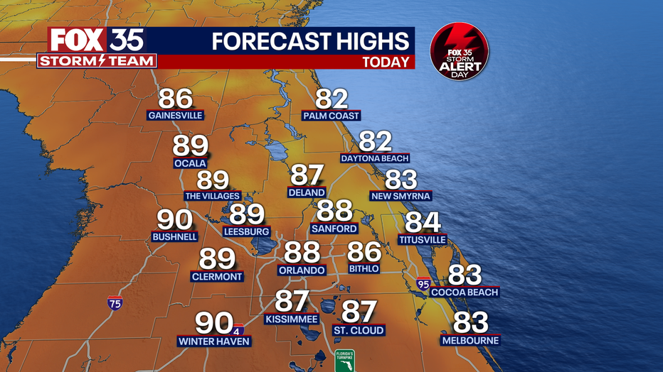
Today's high: 88 degrees
Tonight's low: 70 degrees
BEACHES: We have another stormy evening at the beaches. Showers and storms will spark up after 3pm with chances increasing by the hour from that point on. Highs hit the low-80s seaside with active afternoon skies continuing. Gusty winds, hail, heavy rain and cloud to ground lightning will all be issues.
THEME PARKS: Warm and humid day at the theme parks on this Thursday. Afternoon highs will reach 88 degrees. Showers and thunderstorms develop mainly after 2-3pm. The severe weather risk will increase during this time. Threat will include heavy rain, lightning, hail and possible damaging winds. Stay weather aware and when that thunder roars, you should head indoors immediately.

Severe weather brings rain, damaging hail and winds
A deluge of hail was dropped across East Central Florida within an hour, according to the National Weather Service. The NWS offices in Melbourne observed several rounds of dime-to-penny-sized hail was observed, reaching up to quarter sized just before the storm moved out of the area, forecasters said.
OUTLOOK: Stormy weather will continue across central Florida heading into the weekend. Plenty of passing energy from the Gulf combined with local factors, including the seabreeze, that will drive the storm risk.
We've declared Friday a FOX 35 STORM ALERT DAY. Strong storms on Friday will be possible both during the morning and into the afternoon hours as yet another front moves into the area. Heavy rain, gusty winds and hail will remain the primary threats during this time. Showers and isolated storms will be possible again Saturday and Sunday so stay tuned for details in the coming days ahead. Depend on the FOX 35 Storm Team.