Tropical Storm Nicole timeline: What to expect when tropical storm makes landfall
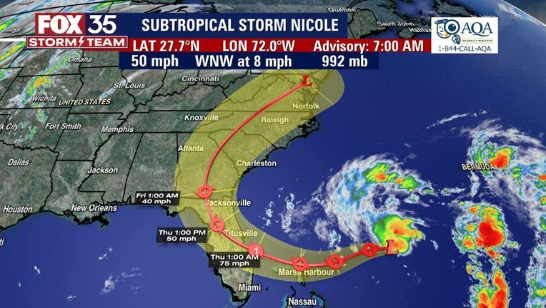
Tropical Storm Nicole is expected to make landfall on the eastern coast of Florida as a strong and dangerous storm – possibly a category 1 hurricane – bringing with it heavy rainfall, flooding, dangerous storm surge, and damaging winds.
The storm is expected to make landfall on Thursday. Storm surge, flooding, and beach erosion are concerns, especially along the coast, and several counties and towns are under storm surge watches and warnings, tropical storm watches and warnings, and hurricane watches and warnings.
TRACKING THE TROPICS
- LIST: Schools closing ahead of Tropical Storm Nicole
- Sandbags: Where to get sandbags in Central Florida
- Orlando Hurricane Center: Latest tropical forecasts, spaghetti models, maps, and NHC forecast cone
- Continuing coverage: Latest stories and forecasts on Subtropical Storm Nicole
- FOX 35 Storm Team Center: Daily weather forecast, hour-by-hour forecast
Check to see the impacts your area may experience in the coming days below:
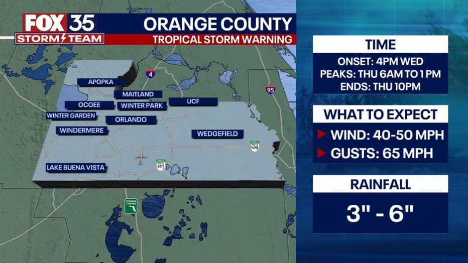
Orange County
Orange County residents can expect impacts Wednesday through Thursday. Those impacts include 65 mph gusts and wind speeds of 40 to 50 mph. The area could see more than three inches of rainfall.
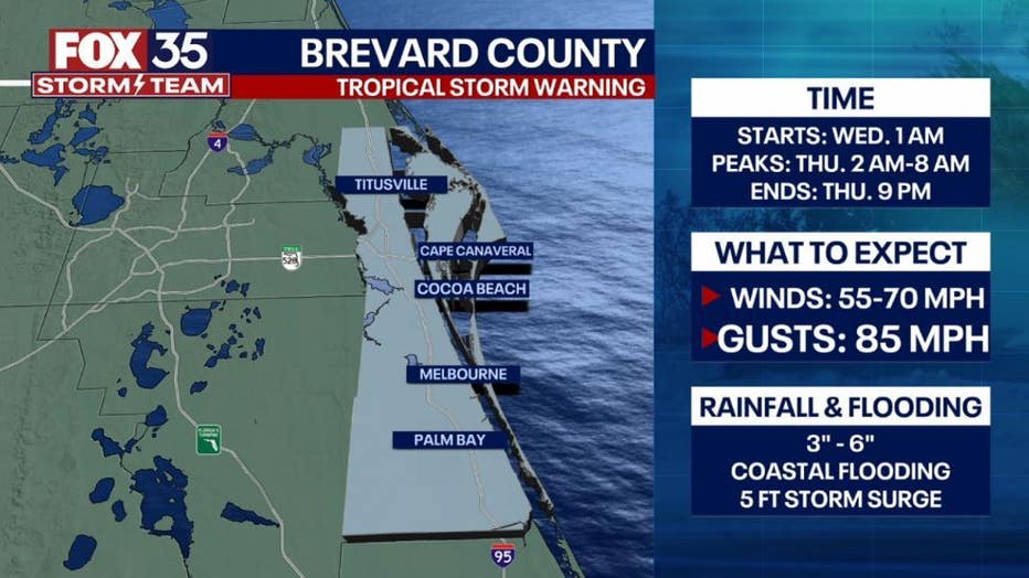
Brevard County
Storm impacts are expected Wednesday through Thursday in Brevard County. Those impacts include 85 mph gusts and wind speeds of 55 to 70 mph.
The area could see over three inches of rainfall.
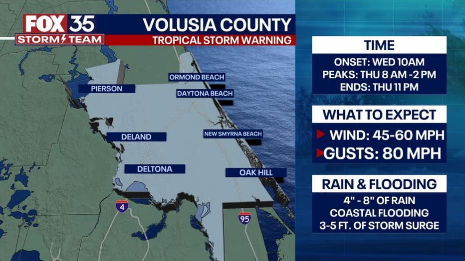
Volusia County
Volusia County residents can expect impacts Wednesday through Thursday. Those impacts include 80 mph gusts and wind speeds of 45 to 60 mph. The area could see over four inches of rainfall.
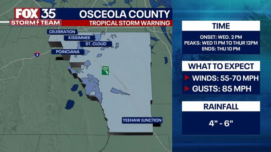
Osceola County
Storm impacts are expected Wednesday through Thursday in Osceola County. Those impacts include up to 85 mph gusts and wind speeds between 55 -70 mph. The area has the potential to see over four inches of rainfall.
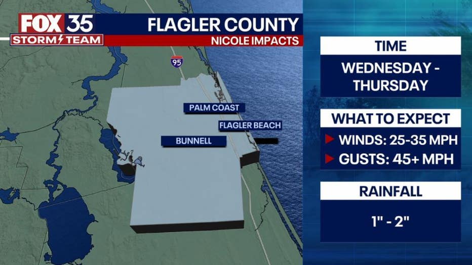
Flagler County
Flagler County residents can expect impacts Wednesday through Thursday. Those impacts include 45+ mph gusts and wind speeds of 25 to 35 mph. The area could see up to two inches of rainfall.
Potential storm impacts as of Monday, Nov. 7 at 10 a.m.
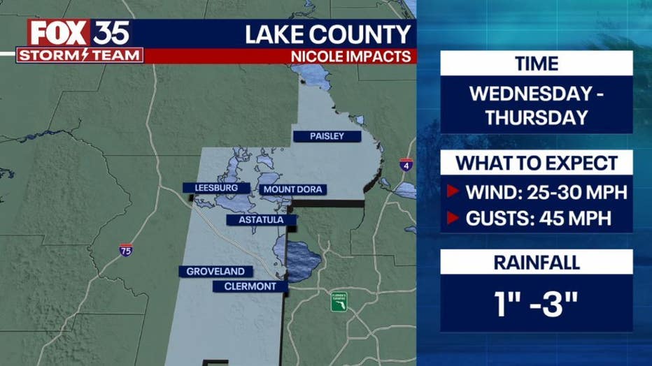
Lake County
The county can expect impacts Wednesday through Thursday. Those impacts include 45 mph gusts and wind speeds of 25 to 30 mph. The area could see up to three inches of rainfall.
Potential storm impacts as of Monday, Nov. 7 at 10 a.m.
Levy County
Levy County residents can expect impacts Wednesday evening/night through Friday morning. Those impacts include 40 mph gusts and wind speeds of 25 to 30 mph. The area could see up to three inches of rainfall.
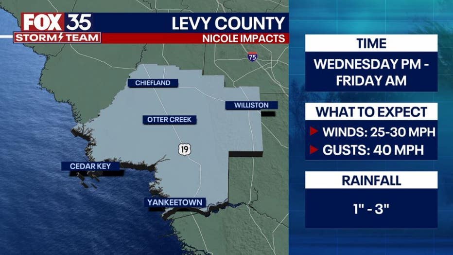
Potential storm impacts as of Monday, Nov. 7 at 10 a.m.
Marion County
Storm impacts are expected Wednesday evening/night through Friday in Marion County. Those impacts include 50+mph gusts and wind speeds up to 40 mph. The area has the potential to see up to three inches of rainfall.
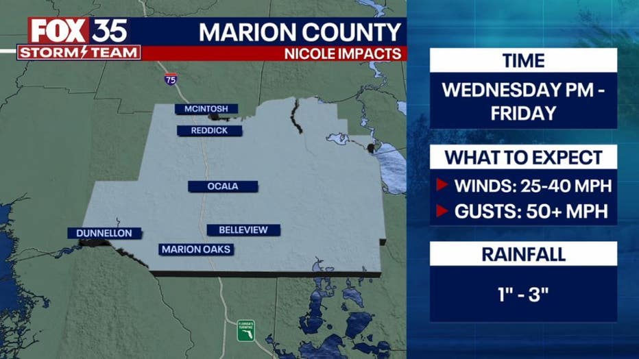
Potential storm impacts as of Monday, Nov. 7 at 10 a.m.
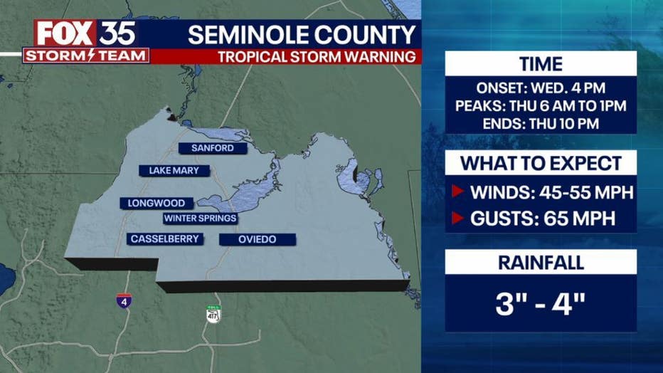
Seminole County
Storm impacts are expected Wednesday through Thursday in Seminole County. Those impacts include 65 mph gusts and wind speeds up to 30 mph. The area has the potential to see over three inches of rainfall.
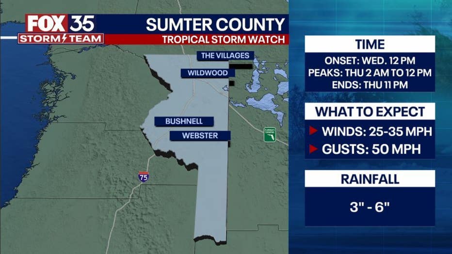
Sumter County
Sumter County residents can expect impacts Wednesday through Thursday evening/night. Those impacts include 50 mph gusts and wind speeds of 25 to 35 mph. The area could see over three inches of rainfall.