

System near the Bahamas has 70% chance of developing, could bring rain to Florida

System could develop into subtropical storm
FOX 35 Chief Meteorologist Glenn Richards is tracking an area of low pressure that is expected to become better organized.
Orlando, FL - While the 2020 Atlantic Hurricane Season doesn't officially begin until June 1, it looks like Mother Nature has some different plans.
For the fifth consecutive year, the tropics are heating up before the starting gun goes off and all eyes will be on the Atlantic this weekend.
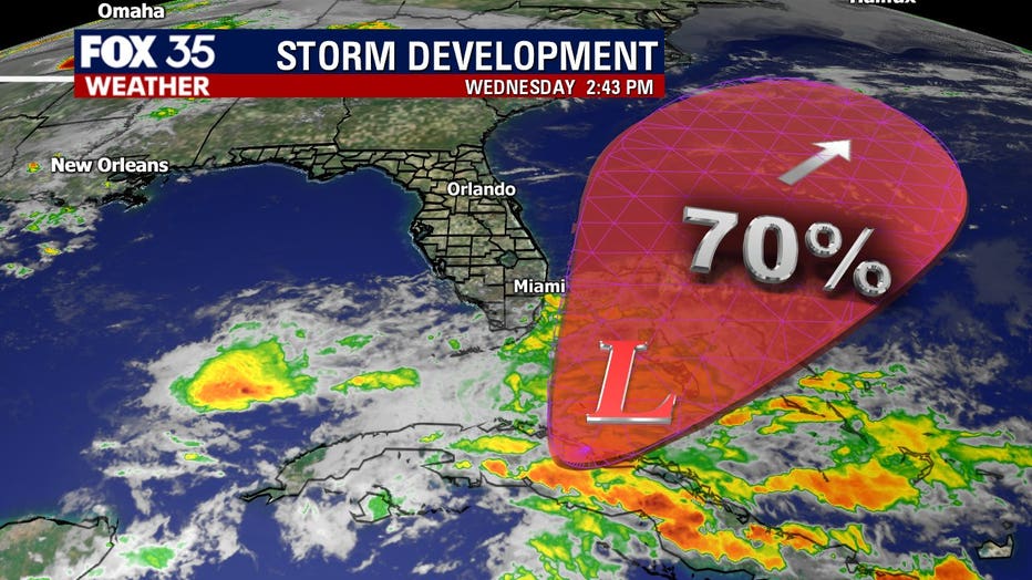
An area of low pressure is forecast to develop near the Bahamas by late week and into Saturday and Sunday. If we see a named storm out of this, the system will be crowned "Arthur", a subtropical storm -- our first of the season.
"The developing sub-tropical low near the Bahamas will strengthen this weekend as it begins to pull away from our Florida east coast," said FOX 35 Chief Meteorologist Glenn Richards.
The National Hurricane Center says the system has a 70% chance of developing over the next five days.
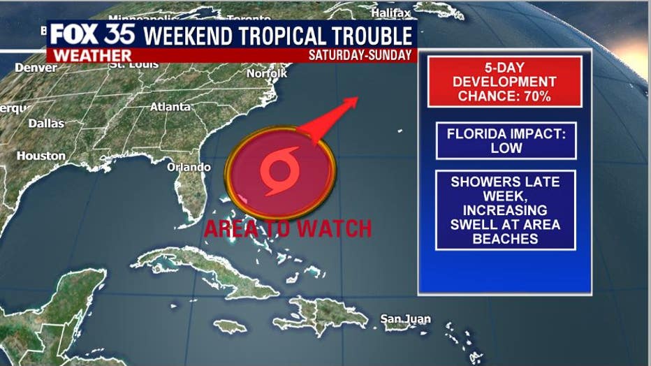
The system could feature winds of over 39 miles per hour over the open ocean as it moves Northeast, away from Florida and into the Atlantic.
RELATED: National Hurricane Center: List of 2020 hurricane names
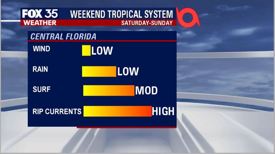
There will be some local impacts, mainly over the coastal waters and along our beach fronts. Threats to the area from wind are extremely low. Winds will actually decrease on Saturday and Sunday as the developing storm moves away.
"We can expect windy weather through Saturday with periods of showers lashing our coastline. The main impact for us will be a very rough surf with dangerous rip currents," Richards added. "By Sunday afternoon, the winds will ease up with dry and hot conditions moving in."
Rainfall impacts will be low as well, with perhaps some scattered showers developing on Friday and Saturday. The highest coverage will be across South Florida as moisture streams north from the Florida straits.
RELATED: 2020 Atlantic hurricane season could be one of the ‘most active on record,’ expert says
We do expect an increase in the ocean swell in Central Florida beaches as powerful waves radiate out from the center of the departing system. Rip currents are likely and the threat is high, especially between 6 a.m. and 12 p.m. on both Saturday and Sunday.
"The developing sub-tropical low near the Bahamas will strengthen this weekend as it begins to pull away from our Florida east coast. We can expect windy weather through Saturday with periods of showers lashing our coastline," FOX 35 Chief Meteorologist Glenn Richards said. "The main impact for us will be a very rough surf with dangerous rip currents. By Sunday afternoon the winds will ease up with dry and hot conditions moving in."
Be sure you have the FOX 35 Weather App downloaded and ready for hurricane season.