

National Hurricane Center flags area to watch for possible tropical development as system soaks Gulf

Tropical update: July 23, 2025
FOX 35 meteorologist Jessica Dobson has the latest conditions in the tropics. The 2025 Atlantic Hurricane Season runs July 1 - November 30. Download the FOX Local app for tropical alerts and notifications.
ORLANDO, Fla. - The National Hurricane Center (NHC) has flagged an area of low pressure to watch along the southeastern United States coastline, which has the possibility of developing into a tropical system later this week.
Here's everything we know about the system and its potential impacts.
What is the system? Where is it located?
What we know:
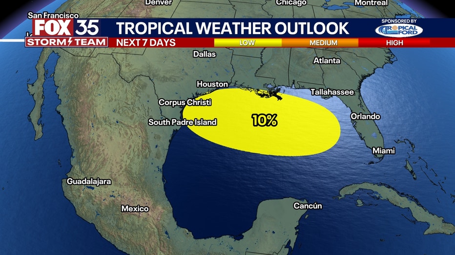
The NHC is tracking a trough of low pressure near the southeastern U.S. coast, which is producing disorganized showers and thunderstorms.
Over the next day or two, the system is forecast to move west-southwestward into the north-central portion of the Gulf, where some slow development is possible.
CLICK TO DOWNLOAD THE FOX LOCAL APP
By this weekend, the system is likely to move inland, ending its chances for development.
Weather experts are currently giving the system a 10% chance of development over the next 48 hours and seven days.
How could the system impact Florida?
Dig deeper:
Regardless of tropical cyclone formation, the FOX 35 Storm Team says locally heavy rainfall is possible for portions of Florida over the next day or so.
This weather is also possible for the northern Gulf through this weekend.

About 2-3 inches of rain could fall across much of the northern Gulf, with some locally higher amounts.
Widespread flash flooding isn’t expected, but isolated flooding could pop up in pockets of heavy precipitation sitting over an area for too long.
SIGN-UP FOR FOX 35'S BREAKING NEWS, DAILY NEWS NEWSLETTERS
The southerly flow along the northern Gulf will likely last for days, which will also lead to an increased risk for rip currents along area beaches.
According to weather experts, a medium risk of rip currents is expected along the Florida Panhandle from Destin to Port St. Joe, as well as along the Atlantic coast from Daytona Beach southward through Melbourne and West Palm Beach, through the last weekend of July.
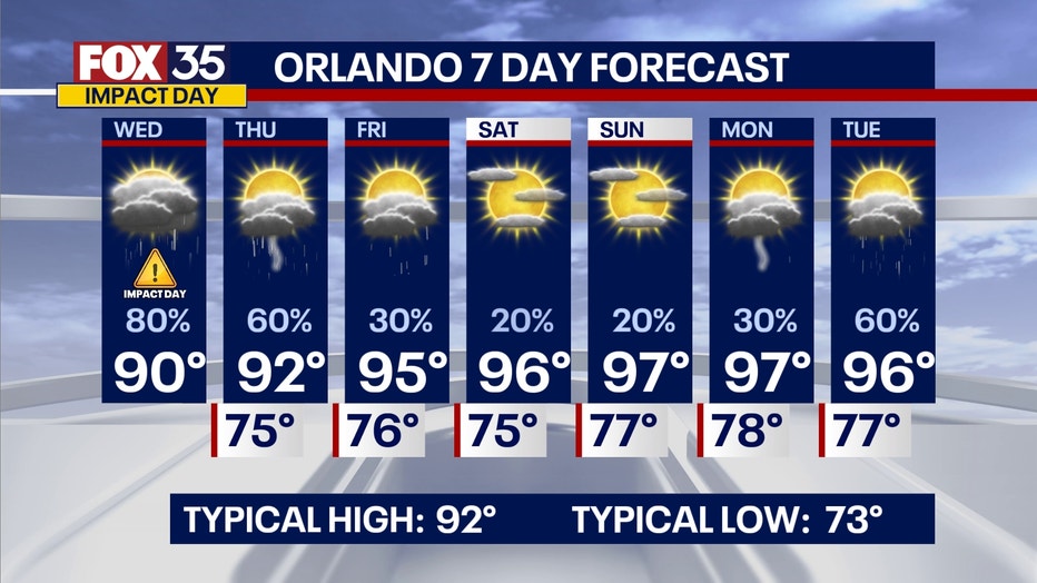
What will the weather look like in Orlando today?
Local perspective:
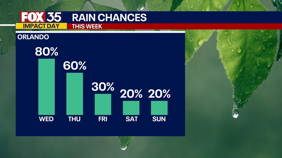
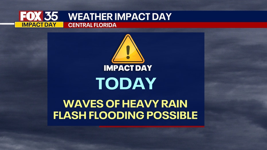
Because scattered showers and storms are likely this afternoon, bringing with it multiple waves of heavy rain, the FOX 35 Storm Team has designated Wednesday as a Weather Impact Day.
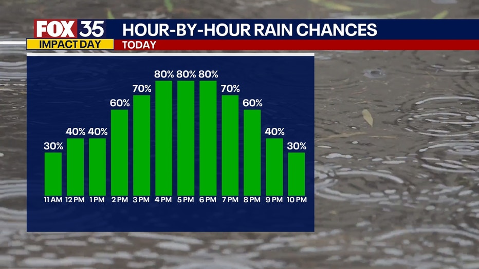
Showers will begin later Wednesday morning, with the highest chances of the heaviest rain taking place from around 2-9 p.m.
Areas to the west of Interstate 95 have the highest chance of showers and storms.
An additional 1-3 inches will be possible for many areas across the region.
With tropical moisture at play, a lot of rain will fall over short periods of time. This could lead to a few isolated areas picking up more than 4 inches of rain, which could lead to the risk of flash flooding.
Any lingering showers and storms will slowly dwindle and fade overnight.
What's next:
Rain and storm chances will taper off as drier air begins to filter in.
By Friday, only a few isolated to scattered showers and storms will be possible.
The Source: This story was written based on information shared by the National Hurricane Center (NHC), FOX Weather and the FOX 35 Storm Team.