

National Hurricane Center: New area possible for tropical development off East Coast

Tropical update: August 2, 2025
FOX 35 Meteorologist Laurel Blanchard has the latest conditions in the tropics. The 2025 Atlantic Hurricane Season runs thru November 30. Download the FOX Local app for tropical alerts and notifications.
ORLANDO, Fla. - The National Hurricane Center (NHC) has highlighted a new area with the potential for tropical development off the East Coast of the United States.
Here's everything we know about the system and its chances of impacting Florida.
What we know:
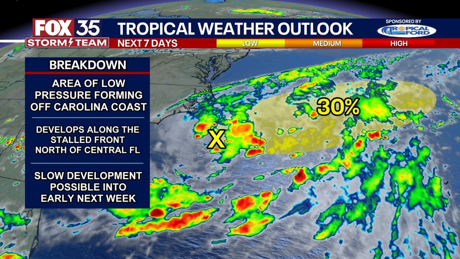
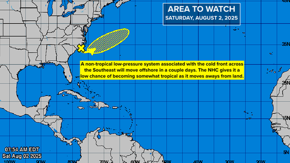
According to an update from the NHC at 2 p.m., an area of low pressure is expected to form later on Saturday or on Sunday along a frontal system off of the Southeastern coast of the U.S. The sytem is currently off the immediate East Coast of North Carolina.
CLICK TO DOWNLOAD THE FOX LOCAL APP
Officials said additional slow development could occur through Monday as the system moves slowly east-northeastward. After that time, environmental conditions become less conductive for development.
Currently, the system has a 30% chance of tropical development in the next 48 hours, and a 30% chance of tropical development in the next seven days.
There is no expectation that this system will pose a threat, but it could be added to the seasonal storm list if it develops winds of at least 40 mph. If the system were to form into a tropical development, the storm would be named Dexter.
(Credit: FOX 35 Storm Team)
Could the system impact Florida?
Local perspective:
The FOX 35 Storm Team says the system will be no threat to Florida, as it is likely to continue on an eastward path and away from any major landmasses.
However, there is a lot of tropical moisture in the atmosphere being pushed off the coast of the Carolinas, and that moisture is what will also be raising our rain chances here in Central Florida.
SIGN-UP FOR FOX 35'S BREAKING NEWS, DAILY NEWS NEWSLETTERS
Periods of heavy rain are likely over the next few days, and some flooding is possible. Here in Central Florida, we will still see heavy rain through the afternoon and evening for the next seven days.
NOAA tropics map. (Credit: NOAA)
Quiet hurricane season so far
Big picture view:
While the tropics are calm at the moment, August is typically when tropical activity starts to increase.
On average, the first hurricane of the Atlantic hurricane season happens within the first two weeks of August, specifically Aug. 11. So far this year, there have been three named storms: Andrea, Barry and Chantal.

2025 Atlantic hurricane season: What to expect
The 2024 Atlantic hurricane season ended with 18 storms, 11 tropical storms, and 5 hurricanes – 3 of which made landfall in Florida (2 as major hurricanes). The 2025 hurricane season is a few months away (Feb. 21 marks 100 days until June 1, the official start of the hurricane season).
However, none have threatened or made landfall in the U.S.
The U.S. Climate Prediction Center (CPC) issues weather outlooks for 2-3 weeks out, while the NHC issues alerts seven days out.
RELATED: Tropical outlook eyes Florida for possibility in mid-August: Climate Prediction Center
In its latest tropical outlook, the CPC is looking at the possibility of tropical activity on either side of Florida sometime between Aug. 6-12.
Since it's outside the NHC's seven-day window, the NHC has not issued any tropical outlooks for the same area.
The Atlantic hurricane season officially runs from June 1 to Nov. 30.
The Source: This story was written based on information shared by the National Hurricane Center (NHC) and the FOX 35 Storm Team on Aug. 2, 2025.