

Orlando weather: Afternoon showers and storms to bring rain, lightning, hail and gusty winds

Orlando Weather Forecast PM: June 28, 2025
FOX 35 Meteorologist Laurel Blanchard has your weather forecast for the rest of the weekend and takes a quick look ahead to the 4th of July.
ORLANDO, Fla. - The widespread afternoon showers and storms we've been experiencing this week will continue through our weekend here in Central Florida, bringing torrential rain, frequent lightning, a little hail and gusty wind.
Here's a look at what to expect from the weather tonight, tomorrow and heading into next week.
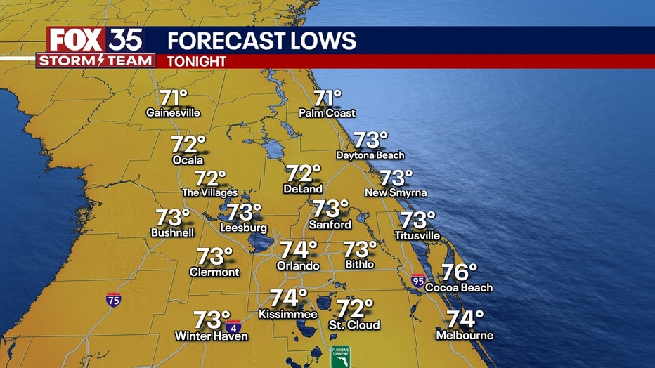
What will the weather look like tonight?
What To Expect:
An area of low pressure in the upper atmosphere is continuing to impact us in Central Florida, bringing widespread storms for the rest of the weekend.
The lift from this along with the sea breeze interaction will fire up widespread storms for the rest of the afternoon and evening. These will linger through the evening and into the early part of the overnight.
The main threats coming with these storms will include torrential rain, frequent lightning, some small hail and gusty winds.
The lows for tonight will fall into the mid-70s with partly cloudy skies later on.
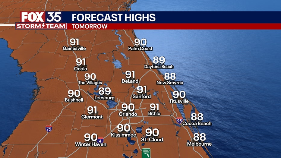
What will the weather look like tomorrow?
What's next:
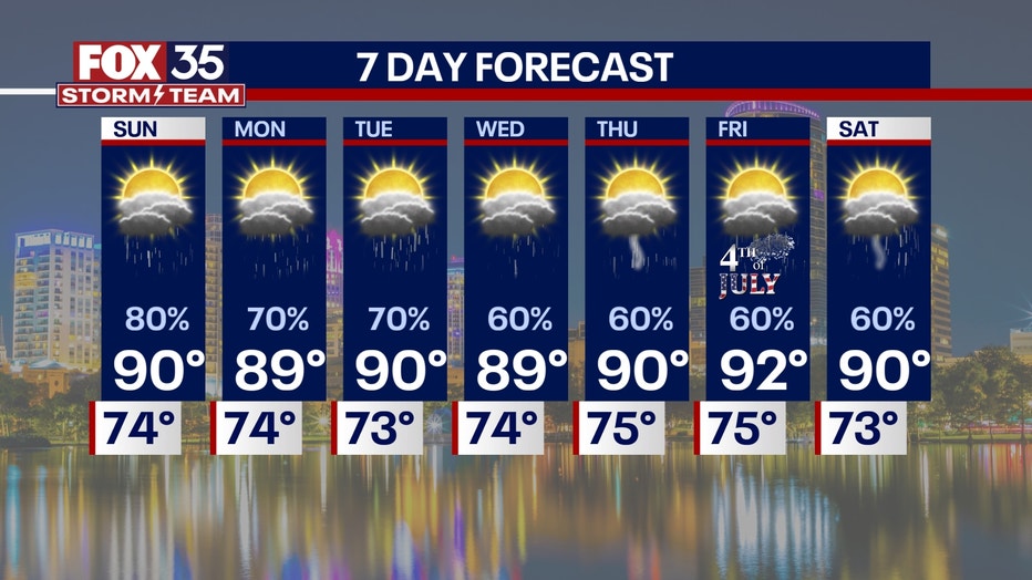
Sunday's weather looks to be a repeat of Saturday's.
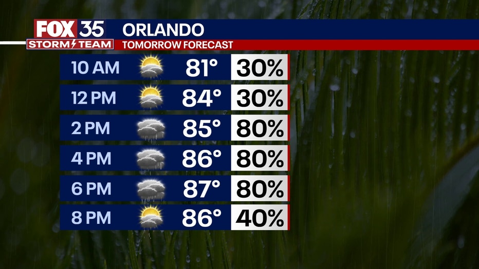
The day will start off with partly cloudy skies, but temperatures will heat up quickly.
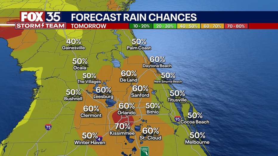
The upper-level low hangs around and will influence some storms to fire up in the afternoon at about 2 p.m. and last through the late evening to early overnight. The storms will develop along the Interstate 75 corridor and move towards the Interstate 95 corridor in the evening.
However, the storms should quiet down in the early overnight hours, leaving partly cloudy skies and muggy conditions later on.
The lows will drop into the low-to-mid-70s.
What will the weather look like next week?
Dig deeper:
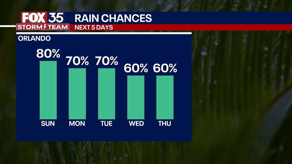
This low will not let up for most of the work week, keeping our afternoon rain chances high.
With this and the seabreezes, the storms will fire up and become widespread through the afternoon and evening hours.
The mornings will start off with partly cloudy skies as temperatures heat up quickly, but be aware of afternoon storms.
Highs will be just a smidge cooler in the upper-80s and low-90s with overnight lows being in the low-and-mid-70s.
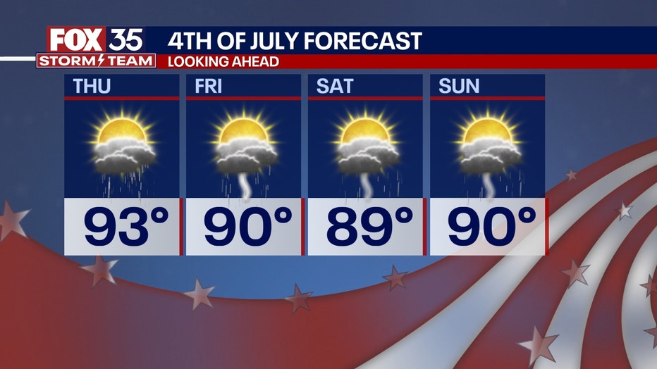
This trend continues to hold all of next week and even into next weekend, so an early heads up for any 4th of July plans!
FOX 35 Storm Tracker Radar and Live Weather Cameras
Track live when storms move across your area using the FOX 35 Storm Tracker Radar below. You can also watch as heavy rain moves across Central Florida on our Live Weather Cameras' page here.

More radar maps from FOX 35 Storm Tracker Radar
- Brevard County
- Flagler County
- Lake County
- Marion County
- Osceola County
- Orange County
- Polk County
- Seminole County
- Sumter County
- Volusia County
- U.S./National Radar
The Source: This story was written based on information shared by the FOX 35 Storm Team on June 28, 2025.