

Orlando weather: Evening thunderstorms possible across Central Florida; See live radar

Orlando Weather Forecast PM: May 12th
FOX 35 Storm Team Meteorologist Noah Bergren is tracking a recap of the significant rain that fell for some areas in the past few days.
ORLANDO, Fla. - Monday night brings another round of showers and storms.
FOX 35 Storm Tracker Radar
Track live when storms move across your area using the FOX 35 Storm Tracker Radar below.

What will the weather look like tonight?
What to expect:
Small chance for a few thundershowers to pop this evening north of the I-4 corridor. Very small chance one could be strong or severe but not too worried.
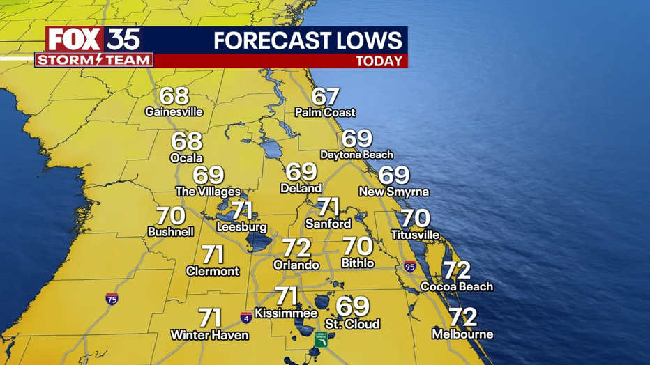
Otherwise, patchy fog may develop overnight with temps. falling into the 60s.
What will the weather look like tomorrow?
Brighter with a partly cloudy sky and a bit of a west-northwest breeze. Afternoon highs in the mid 80s with a passing rain shower possible.
What will the weather look like the rest of the week?
Starting Wednesday it is mostly sunny, dry, and getting hot. The heat really cranks this weekend into next week, with mid-upper 90s air temps. expected, which will be record-setting in some areas. Not heat index, but actual air temperature 94-98 this weekend into early next week.
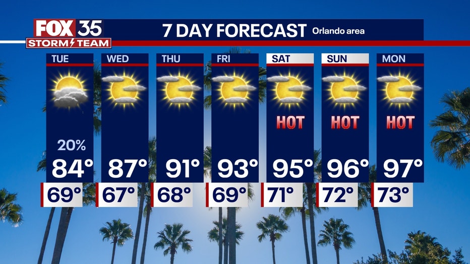
After Tuesday's small chance for a rain shower, things look dry as far out as we can reliably tell. Back to a dry, but this time, very hot pattern.
The 90s may stick around too into a good portion of next week before any noticeable cool down in the temps comes around.
More radar maps from FOX 35 Storm Tracker Radar
- Brevard County
- Flagler County
- Lake County
- Marion County
- Osceola County
- Orange County
- Polk County
- Seminole County
- Sumter County
- Volusia County
- U.S./National Radar
Stay connected with FOX 35
- Download the FOX 35 News app for latest news, weather, and traffic alerts
- Download the FOX 35 Storm Team Weather app for live, interactive radar
- Visit FOX35Orlando.com/weather for interactive radar, plus updated weather graphics, maps, and images
The Source: This story was written based on information shared by the FOX 35 Storm Team on May 13, 2025.