

Orlando weather: Cooler temps, partly cloudy skies ahead of 2025 hurricane season on Sunday

Orlando PM Weather Forecast: May 31, 2025
FOX 35 Storm Team Meteorologist Laurel Blanchard breaks down what is in store for the rest of a weekend after a stormy start.
ORLANDO, Fla. - Cooler temperatures and partly cloudy skies are on tap for Saturday night, welcoming in the start of the 2025 hurricane season on Sunday.
Here's everything you need to know about the weather tonight, tomorrow and to start the workweek.
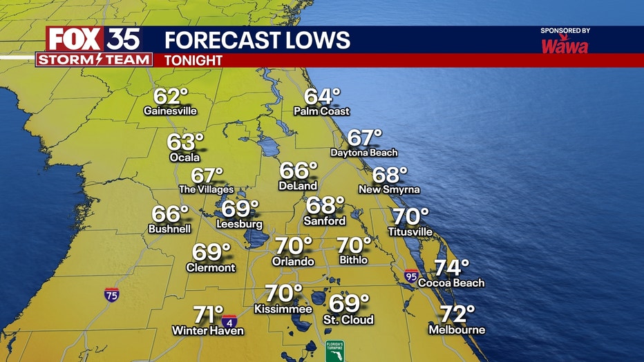
What will the weather look like tonight?
What To Expect:
After an active start to the weekend, things have really calmed down for the end of our Saturday.
Partly cloudy skies linger through the rest of the evening and overnight as some cooler air starts to tap into the region, cooling down our temperatures and taking down the humidity.

Saturday 5/31 Storm Recap
Meteorologist Laurel Blanchard breaks down the strong storms from earlier this morning.
Lows tonight will linger in the upper 60s and low 70s. This cold front looks to stall out over southern Florida and will keep the possibility of a pop-up of a few showers and storms throughout the overnight and rest of the weekend.
However, the chances of these storms becoming severe are low at this time. Storms will stick to the south of the Orlando area and mainly stay over Southern Brevard and Osceola counties if we do see isolated storms pop up.
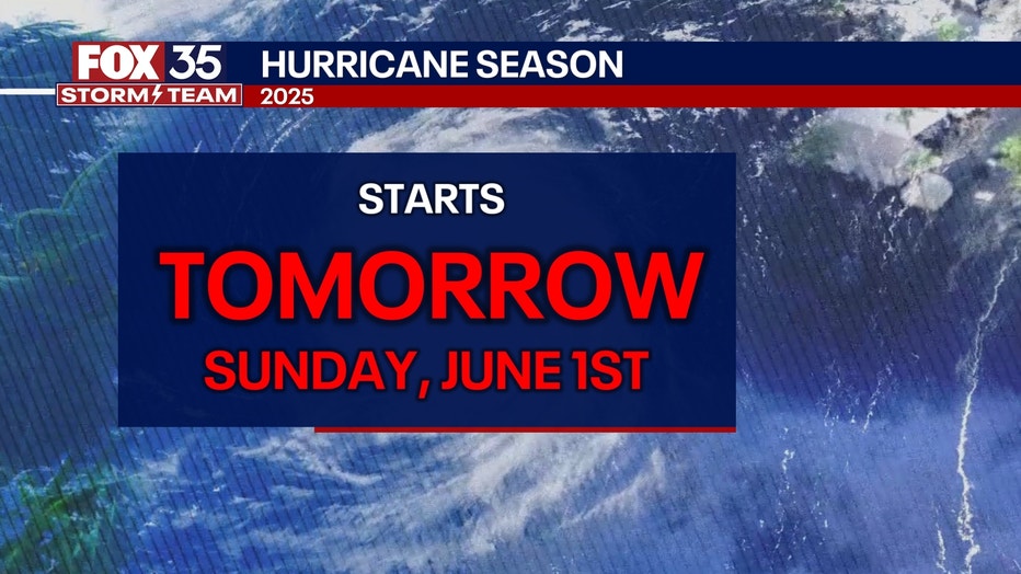
Hurricane season begins
What's next:
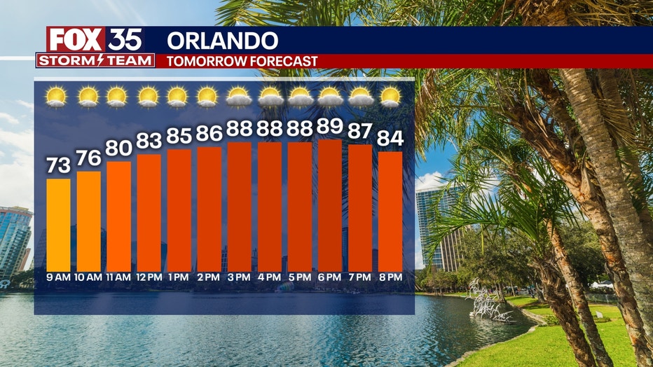
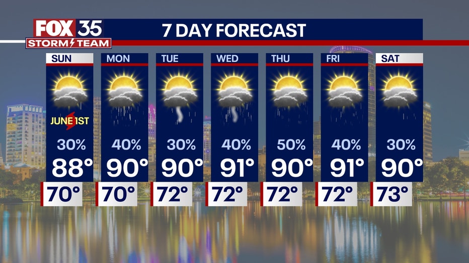
Tomorrow, June 1, marks the start of the 2025 hurricane season.
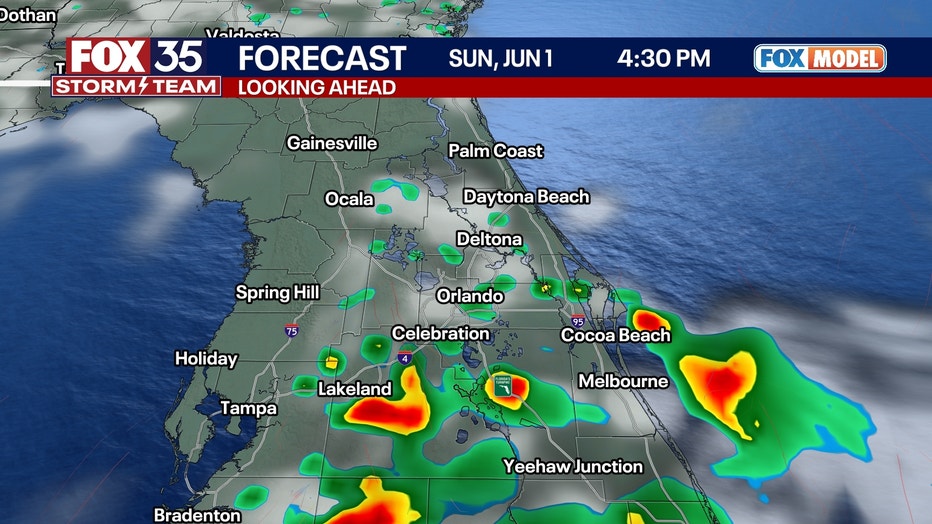
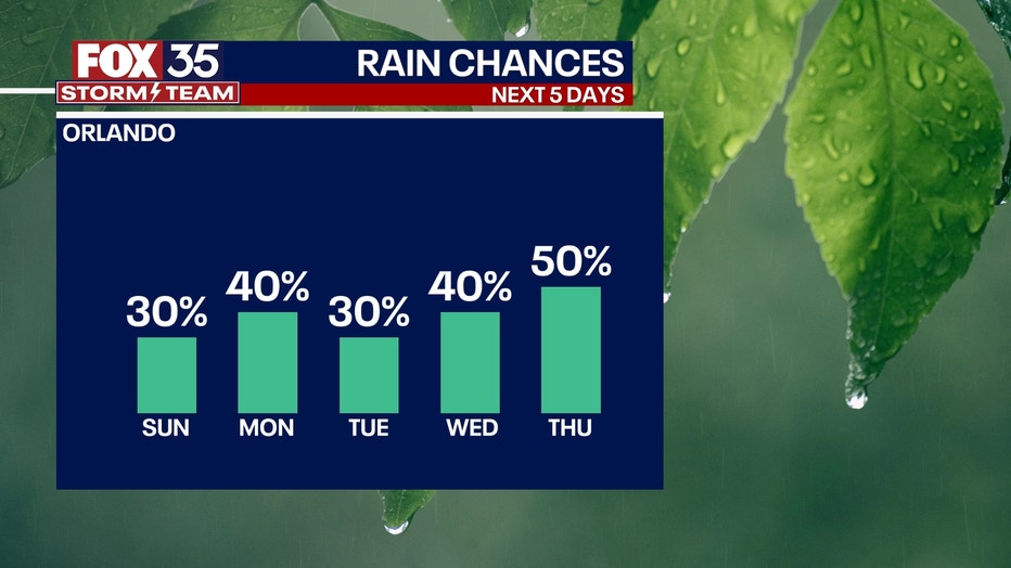
Rain chances remain low on Sunday with only a pop-up shower or stray thunderstorm.
This is due to the front that moved through on Saturday stalling to our south and possibly firing up a few storms south of the metro.
Highs will bump back into the upper 80s with partly cloudy skies.
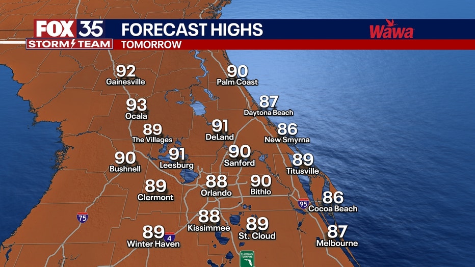
Few clouds will stick around Sunday night with lows in the low 70s.
What will the weather look like next week?
Dig deeper:
The front that moved through Saturday still seems to linger over the state headed into Monday.
A wave of energy once again brings the possibility of storms Monday of showers and storms through Monday afternoon.
We fall back into the typical afternoon seabreeze-driven showers and thunderstorms starting to take back hold on Tuesday through next week.
Highs look to stay close to seasonable norms for this time of year, topping out near 90° with lows in the low 70s.
Something else that will be picking up next week will be the Saharan Dust sweeping off the coast of Africa, especially midweek. This could decrease air quality, firing up those who have allergies and make for a more milky and muted look to our normally brilliant blue skies. On the bright side, it will make for more vivid and colorful sunrises and sunsets and keep hurricane activity at bay for the first week of June.
FOX 35 Storm Tracker Radar and Live Weather Cameras
Track live when storms move across your area using the FOX 35 Storm Tracker Radar below. You can also watch as heavy rain moves across Central Florida on our Live Weather Cameras' page here.

More radar maps from FOX 35 Storm Tracker Radar
- Brevard County
- Flagler County
- Lake County
- Marion County
- Osceola County
- Orange County
- Polk County
- Seminole County
- Sumter County
- Volusia County
- U.S./National Radar
STAY CONNECTED WITH FOX 35 ORLANDO:
- Download the FOX Local app for breaking news alerts, the latest news headlines
- Download the FOX 35 Storm Team Weather app for weather alerts & radar
- Sign up for FOX 35's daily newsletter for the latest morning headlines
- FOX Local: Stream FOX 35 newscasts, FOX 35 News+, Central Florida Eats on your smart TV
The Source: This story was written based on information shared by the FOX 35 Storm Team on May 31, 2025.