

TIMELINE: Overnight showers usher in cooler temperatures on Saturday across Central Florida

Orlando Weather Forecast: Jan. 12, 2024
A few passing showers can be expected into the overnight hours. Saturday will be a bit cooler than Friday, with highs reaching into the mid and upper 60s.
ORLANDO, Fla. - Friday has been downgraded to a FOX 35 Weather Impact Day due to a lowered risk of a severe storm threat in Central Florida, with passing showers appearing to be the biggest concern.
A warm front is lifting across the area from south to north. This feature injects the region with some additional moisture in the form of clouds and mainly light showers.
As we head into Friday night, we're still watching for a few intense storms, mainly north of Orlando. Heavy rain and gusty winds will be the main offenders in any strong storms that fire off.
Saturday and Sunday bring mixed skies and cooler temperatures in the 60s for daily highs and 40s and 50s for the overnights.
Next week starts with temperatures in the mild 70s and some showers around. Colder air could possibly invade the region by next Wednesday and Thursday.
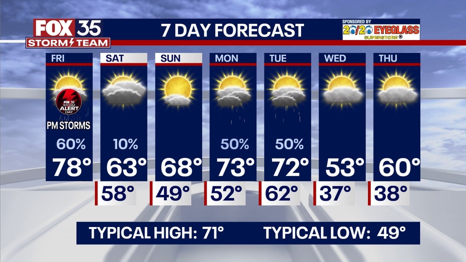
High temperatures during this time could be stuck in the 50s, with overnights in the 30s.
Florida Storm Tracker - Radar Weather Maps
You can track the storms with us. Head over to FOX35Orlando.com/weather or visit the "FOX 35 Storm Tracker Weather Radar & Maps" section in the FOX 35 News app to see updated radar maps for several Central Florida counties.

Stay connected with FOX 35
- Download the FOX 35 News app for latest news, weather, and traffic alerts
- Download the FOX 35 Storm Team Weather app for live, interactive radar
- Visit FOX35Orlando.com/weather for interactive radar, plus updated weather graphics, maps, and images