

When will it rain in Florida? Tropically infused storms drenching state, Southeast through July 4th weekend

Tropical update: July 3, 2025
FOX 35 Meteorologist Laurel Blanchard has the latest conditions in the tropics. The 2025 Atlantic Hurricane Season runs July 1 - November 30. Download the FOX Local app for tropical alerts and notifications.
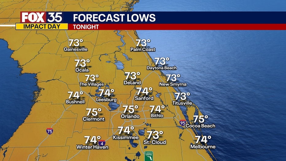
What will the weather look like tonight?
What To Expect:
ORLANDO, Fla. - Rounds of rain and showers with a few thunderstorms will persist through the rest of the evening.
Because of the tropical moisture in the air, expect HEAVY downpours for the rest of the evening. Showers will taper off tonight, leaving mostly cloudy skies and muggy conditions.
Temps will fall in the mid 70s.
What will the weather look like for the Fourth of July?
What's next:
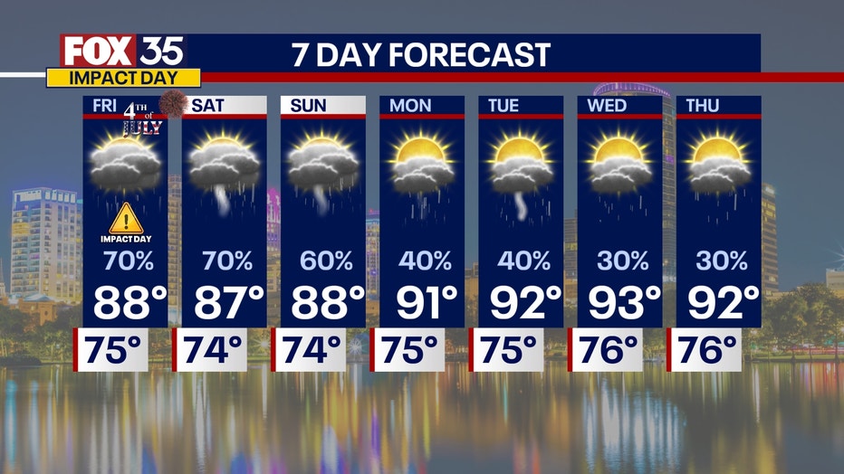
Friday is expected to be a FOX 35 Weather Impact Day.
A stalled front will linger over the Southeast and force tropical moisture over Florida for the 4th. The chance of an area of low pressure forming along the stalled front will help to bring repeated rounds of heavy rain and storms. This also means that we could see a strong or severe storm as these waves of moisture are passing through.
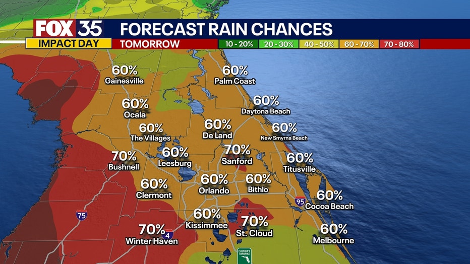
We'll see a 70% chance of rain so while heavy rain is on tap for the 4th of July, this rain could impact the region at all times of the day. It will not be a complete and total washout, but it will most likely impact your 4th of July plans if they are outdoors. There will be some dry spots, but they will not last long before another round of rain rolls in.
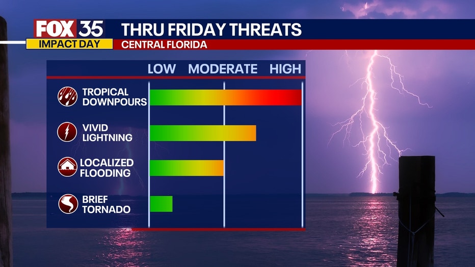
Main threats:
- HEAVY downpours
- Vivid lightning
- Localized flooding
- Gusty winds
- Very low chance of a brief tornado
For the 4th of July holiday specifically, it will be a close call for any fireworks shows as scattered showers will still be likely as the sun sets.
What will the weather look like for the holiday weekend?
Looking Ahead:
With tropical moisture being forced to move over Florida due to the stalled front, it will bring continued waves and rounds of heavy downpours and storms into the weekend.

By the time the weekend wraps up, we're expecting to have accumulated around 3-6" of rain across Central Florida. There will be breaks in the rain, but when it does rain the downpours will be heavy and dump a lot of rain over a short timeframe.
By the back half of the weekend and early next week, we will be watching the chance of tropical development off the Southeast Atlantic coast.
How much rain will the Orlando area get?
Local perspective:
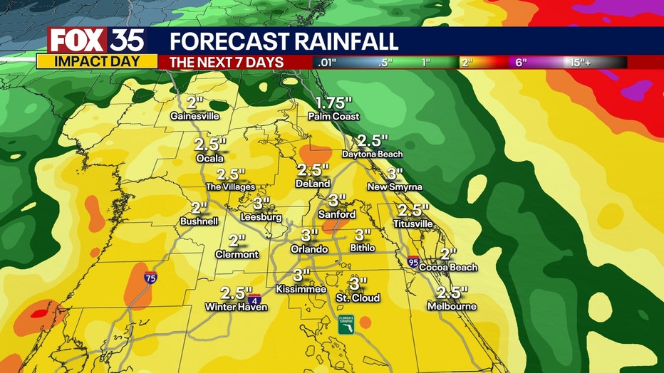
Widespread showers and thunderstorms are expected across Central Florida throughout the week.
Rainfall totals will vary across the region, but several inches are expected to fall in nearly every county by the weekend.
RELATED: TIMELINE: When will tropical rain arrive in Orlando, and how long will it last?
Coastal areas from the eastern Florida Panhandle southward through the Big Bend and into the Sarasota area will likely see the highest rain totals this week. Parts of Florida's Big Bend from about the Perry area through Cedar Key may receive as much as 6 to 10 inches.
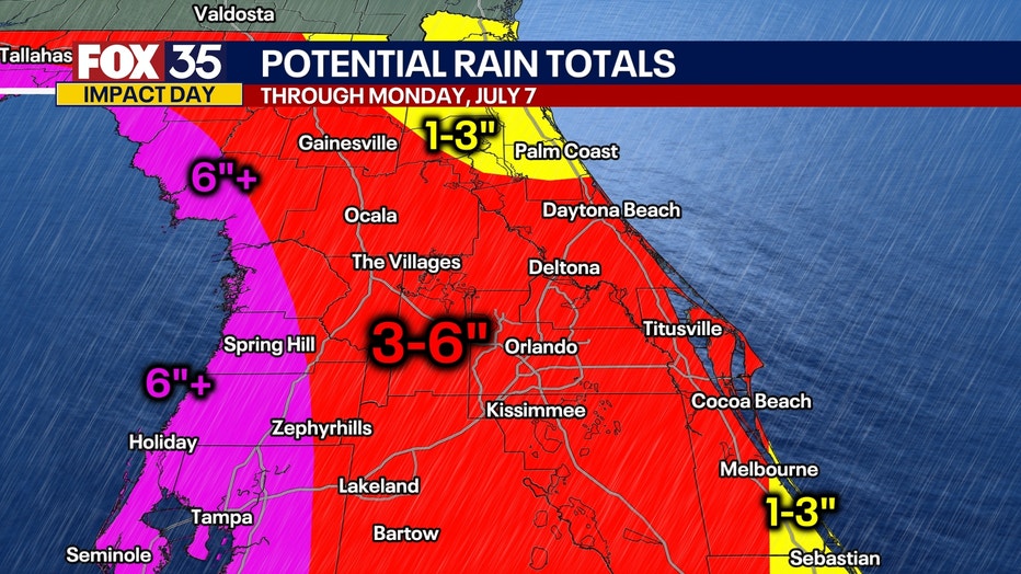
Heavy rain is also expected along the Atlantic Coast of Florida from south of Jacksonville through Daytona Beach, as well as in communities along the Space Coast from Cocoa Beach to Melbourne.
SIGN-UP FOR FOX 35'S BREAKING NEWS, DAILY NEWS NEWSLETTERS
Daily downpours and storms are likely, and meteorologists say the wet weather won’t be confined to the usual afternoon hours.
The exact timing for the heaviest rain still needs to be fine-tuned as we move through this week, but models show several inches of rain could fall over the next seven days. By Saturday, as the tropical moisture moves over the Atlantic Ocean, the chances of a tropical depression forming off the Southeast United States increases.
Big picture view:
AAA projects a record 72.2 million Americans are expected to travel during the July Fourth weekend, driven by the holiday falling on a Friday.
Flooding, rain, lightning, and possible flight delays are poised to impact travel from Florida along the eastern seaboard. Cities from Tampa and Orlando to New York and Boston may see weather-related disruptions, making travel logistics challenging nationwide.
Fireworks will be dampened across Central Florida with the likelihood of heavy rain.
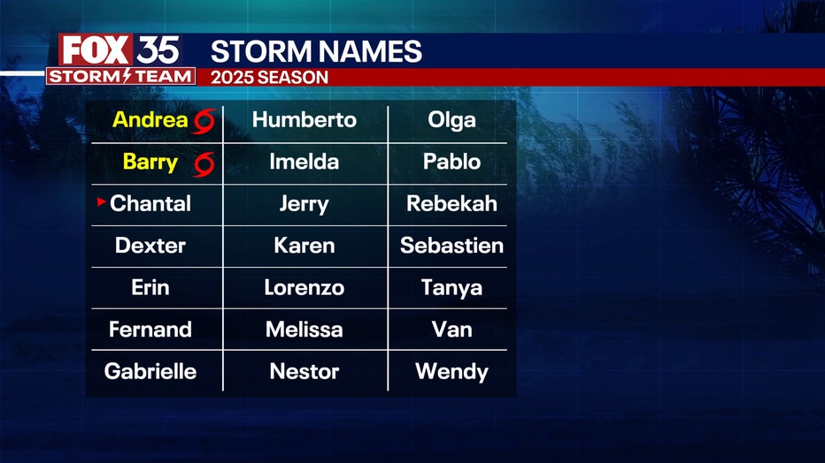
2025 Atlantic storm names
Dig deeper:
Whenever the next named storm develops in the Atlantic Basin, it will get the name Chantal.
FOX 35 Storm Tracker Radar and Live Weather Cameras
Track live when storms move across your area using the FOX 35 Storm Tracker Radar below. You can also watch as heavy rain moves across Central Florida on our Live Weather Cameras' page here.

More radar maps from FOX 35 Storm Tracker Radar
- Brevard County
- Flagler County
- Lake County
- Marion County
- Osceola County
- Orange County
- Polk County
- Seminole County
- Sumter County
- Volusia County
- U.S./National Radar
The Source: This story was written based on information shared by the National Hurricane Center (NHC) and FOX 35 Storm Team on July 3, 2025.