

Central Florida to see mix of heat and storms on Wednesday

Weather Forecast: June 1, 2022
Orlando and Central Florida weather could be greatly impacted by a tropical wave that is hanging around the Yucatan Peninsula.
ORLANDO, Fla. - WHAT IS THE WEATHER FORECAST FOR TODAY AROUND ORLANDO?
Today's forecast high: 89 degrees
Tonight's forecast low: 71 degrees

MAIN WEATHER CONCERNS:
Hot and humid on this Wednesday with upper 80s-near 90 likely inland, 80s along the coast. Showers and storm chances look to remain in the 40% range near Orlando and along the beaches. Higher (50%) from around the theme parks over to the Gulf beaches. Could be a few strong storms west of Orlando. Heavy rain, lightning, gusty winds and hail could all accompany the stronger storms.


WHAT IS THE WEATHER FORECAST FOR WALT DISNEY WORLD, UNIVERSAL, AND SEAWORLD?
On this Wednesday, park visitors can expect hot-humid conditions with high near 90 common during the afternoon. Rain chances will phase in mainly after 11am. Coverage stands at 50%. Heavy rain, lightning, gusty winds could accompany the stronger storms.
WHAT IS THE WEATHER FORECAST FOR THE BEACHES IN CENTRAL FLORIDA?
Wednesday beach side: The day will start with mixed skies with mainly late morning-early PM showers and storms, coverage around 40%. Temperatures at the beaches will be in the mid 80s. Surf will be around 2ft or less with a moderate rip current risk. Winds will be out of the East at 5-15 mph.
LOOKING AHEAD:
Hot, humid and downright tropical weather conditions will dominate the extended forecast.
Highs near 90 and super high humidity. Rain chances will move up and down through the week as daily waves of moisture are guided through the region.
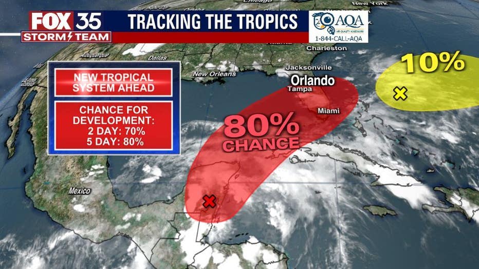
The FOX 35 Storm Team is watching the tropics as we head into the weekend. While a tropical system has yet to form as of Wednesday morning, the odds are increasing with the 2-day outlook indicating a 70% chance of development and the 5-day outlook at 80%.
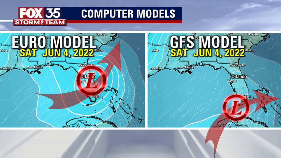
A depression looks likely to form in the Southeast Gulf soon, a named storm "ALEX" is also possible. "ALEX" would be the first named storm of the 2022 Atlantic Hurricane Season. Depending on the track, Central Florida could see a lot of rain this weekend or very little. Current GFS forecast modeling is suggesting a southern route, lessening impacts locally. The European modeling is showing more impacts and a passage through the Central Peninsula. The Euro track would really increase rain coverage with some chunky totals possible....stay tuned!