

Central Florida record-challenging heat wave: How hot will it get over the next few days?

Record-breaking heat wave hitting Central Florida
An intense heat wave is hitting Centra Florida this weekend and heading into next week. FOX 35 Storm Team Meteorologist Noah Bergren has all the details on how hot it will get, as well as how long the heat wave is expected to last.
ORLANDO, Fla. - Central Florida is currently experiencing a dangerous heat wave, with temperatures expected to challenge record highs in multiple counties.
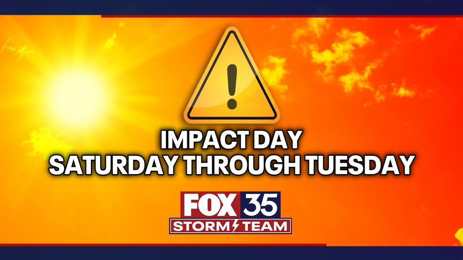
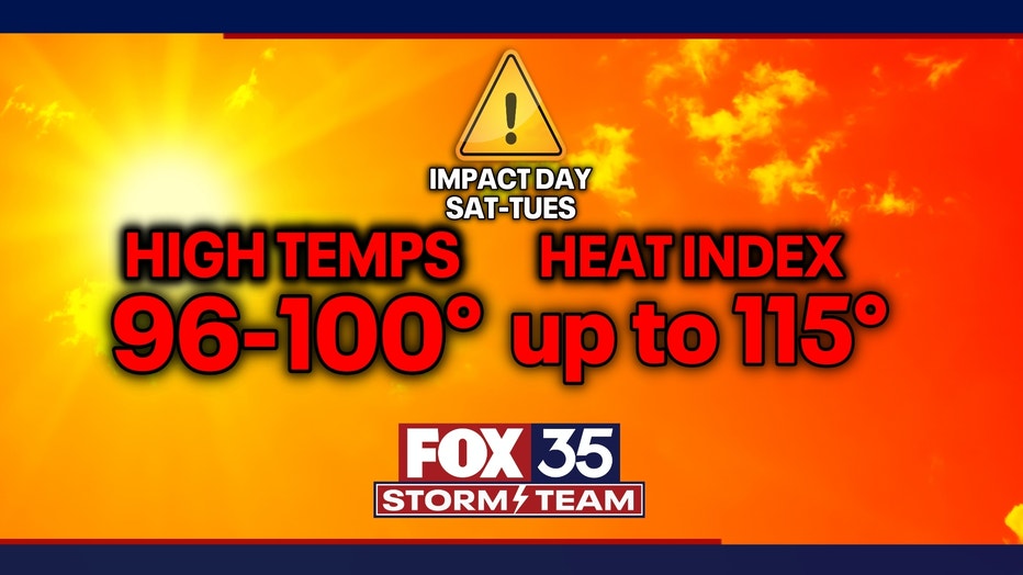
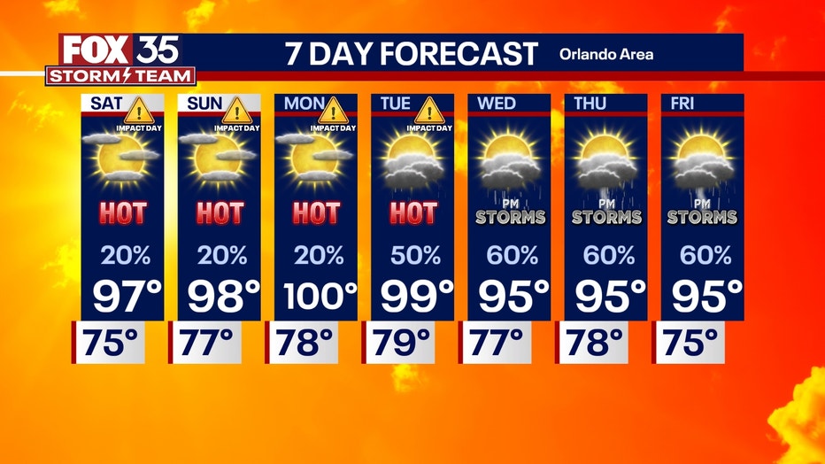
The FOX 35 Storm Team has designated Saturday through Tuesday as Weather Impact Days, as temperatures are expected to be between 96-100 inland, with heat index values from 105-115.
Here's everything we know about the record-challenging heat wave and how to protect yourself.
How hot will it get in Central Florida?
What we know:
Highs in Central Florida are forecasted to reach the mid-to-upper-90s, with heat index values (what the temperature feels like with humidity) potentially reaching between 105 and 110 degrees.
The hottest temperatures will be Monday, with highs near 100 inland and in the low-to-mid-90s at the beaches.
CLICK TO DOWNLOAD THE FOX LOCAL APP
Saturday through Tuesday will feature temperatures between 96-100 inland, with heat index values from 105-115.
Rain chances will remain low during the next few days.
Heat Advisories are likely to be issued throughout the weekend and possibly into next week.
Will the heat reach record highs?
The backstory:
The heat wave could be the most intense of the summer so far.
Monday will feature temperatures with highs near 100 degrees.
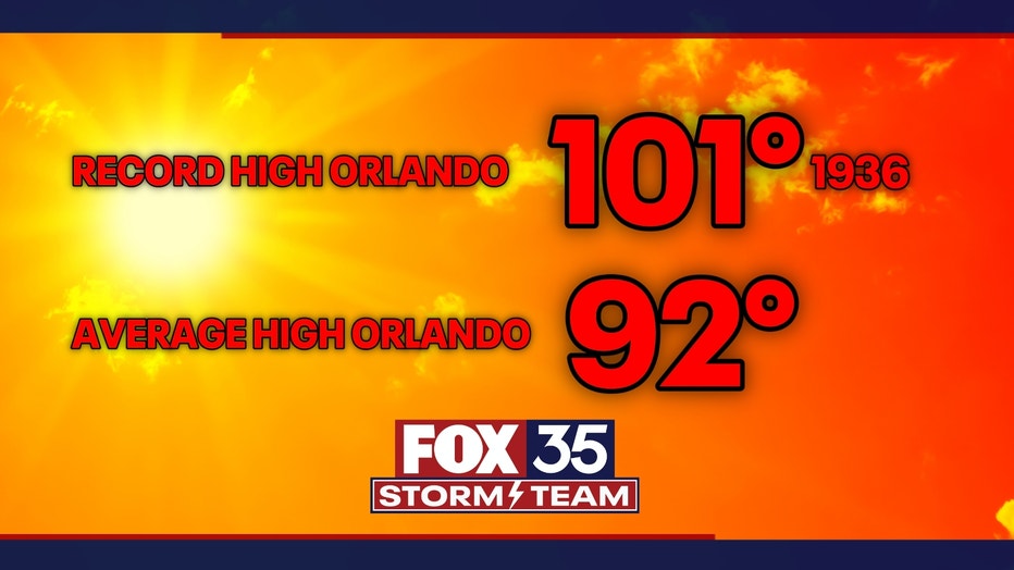
The record high in Orlando was 101 degrees in 1936, so we will come close.
Where is the heat coming from?
Dig deeper:
The heat is being driven by a ridge of high pressure parked over the Atlantic, producing a heat dome effect across much of Florida and the Southeast.
The large-scale weather setup also aids in suppressing sea breeze development, which is a natural source of afternoon and evening cooling, especially in coastal areas.
How can I protect myself from the heat?
What you can do:
The intense heat poses a risk of heat-related illnesses, such as heat exhaustion and heat stroke, especially for vulnerable populations such as the elderly and children.
The National Weather Service (NWS) has several tips to help you stay safe during these intense heat stretches.
Stay Cool Indoors:
- Seek air conditioning: If your home doesn't have AC, find a public cooling center or spend time in air-conditioned spaces, such as libraries or malls.
- Limit oven use: Reduce heat generated indoors by using your oven less.
- Take cool showers or baths: This can help lower your body temperature.
Stay Hydrated:
- Drink plenty of water: Even if you don't feel thirsty, make sure to drink water throughout the day.
- Avoid alcohol and caffeine: These can dehydrate you.
- Consider electrolyte drinks: If you're sweating a lot, these can help replenish lost salt.
SIGN-UP FOR FOX 35'S BREAKING NEWS, DAILY NEWS NEWSLETTERS
Protect Yourself Outdoors:
- Dress appropriately: Wear lightweight, loose-fitting and light-colored clothing.
- Use sunscreen: Apply liberally and reapply every two hours.
- Wear a hat and sunglasses: Protect your face and scalp from the sun.
- Seek shade: When possible, take breaks in shaded areas.
- Limit strenuous activities: Reschedule or reduce outdoor activities during the hottest parts of the day.
- Pace yourself: Don't push yourself too hard, especially during midday.
Check on Others:
- Check on vulnerable individuals: Ensure children, the elderly and those with health conditions stay cool and hydrated.
- Never leave people or pets in parked cars: Temperatures inside a car can rise rapidly, even on a mild day.
Be Aware of Heat-Related Illnesses:
- Know the symptoms: Be aware of the warning signs of heat exhaustion and heatstroke.
- Seek medical attention if needed: If you or someone you know is experiencing symptoms of heat illness, seek medical help immediately.
The Source: This story was written based on information shared by the FOX 35 Storm Team, FOX Weather and the National Weather Service (NWS).