

Florida faces potential heightened risk of intense hurricanes due to marine heat wave
ORLANDO, Fla. - Florida faces a potentially heightened risk of intense hurricanes in the coming season due to a prevailing marine heat wave in the western Atlantic and Gulf, according to FOX 35 Storm Team Meteorologist Brooks Garner.
Marine heat waves impact Florida
What we know:
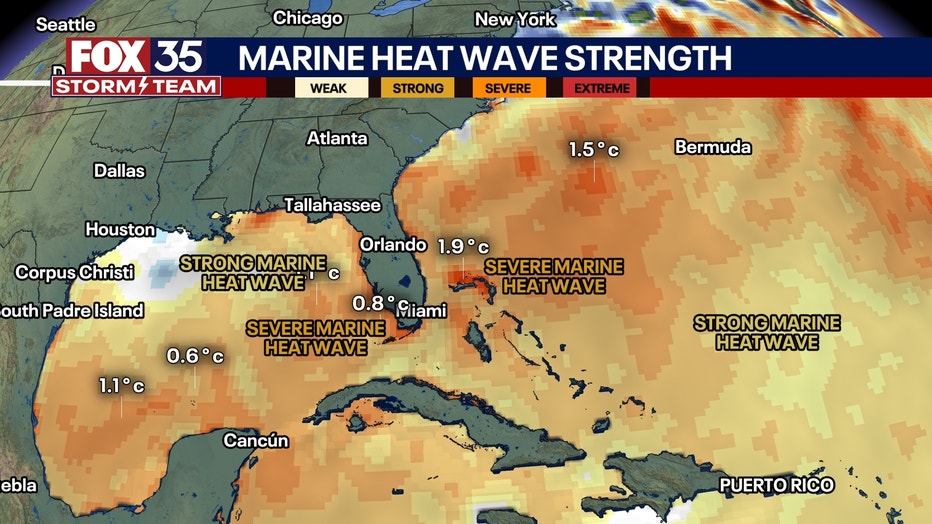
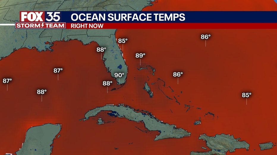
Right now, ocean waters near Florida, the Bahamas, the Florida Keys and the Gulf are experiencing a "marine heat wave." Florida, being a coastal state heavily impacted by hurricanes, faces increased risks due to these marine heat waves.
The abnormally warm ocean waters near Florida and the Keys have already reached temperatures above normal for this time of year. This month, Buoy Key in the Florida Keys recorded a water temperature of 99 degrees.
CLICK TO DOWNLOAD THE FOX LOCAL APP
The backstory:
Last week's intense heat wave over land enhanced this water-warming effect, especially over the Atlantic waters adjacent to Florida and over the entire Gulf.
Last year, both Hurricane Helene and Hurricane Milton were both intensified by marine heat waves.
What's next:
The trend of warmer than normal water is likely to continue for at least the next month.
What they're saying:
"Let's just hope that whatever may come our way later this month steers clear of our area," Garner said. "We should remain hopeful, but must remain ready for the reality that we could face another historic hurricane season in Florida."
What is a marine heat wave?
Dig deeper:
Just like heat waves on land, a marine heat wave is defined as a prolonged period of abnormally high temperatures — but in the ocean. This means sea surface temperatures in those regions are significantly warmer than usual for this time of year.
It's officially considered a marine heat wave when the ocean temperature stays above the 90th percentile of historical averages for at least five consecutive days.
Marine heat waves form when several conditions line up. Calm winds due to high pressure reduce the mixing of cooler deep water with the warmer water at the surface, allowing the top layer to stay hotter for longer. Clear skies and long periods of sunlight add more heat to the ocean.
What does this mean for the hurricane season?
Why you should care:
This increase in ocean heat has serious consequences, especially during hurricane season.
Warm ocean water provides the energy that tropical storms and hurricanes need to grow. The hotter the water, the more powerful these storms can become. When a marine heat wave is present, as it is now, it raises the likelihood that tropical systems could become stronger and more frequent.
Later this month, most global weather models suggest we could see at least several named systems threatening our region of the Atlantic basin, right where this marine heat wave has developed.
SIGN-UP FOR FOX 35'S BREAKING NEWS, DAILY NEWS NEWSLETTERS
For places like Florida and the Gulf Coast, this means a greater risk of significant tropical weather events as we approach the peak of the hurricane season on Sept. 10.
Marine heat waves also affect more than just hurricanes. They can damage coral reefs, disrupt marine ecosystems and shift weather patterns around the globe.
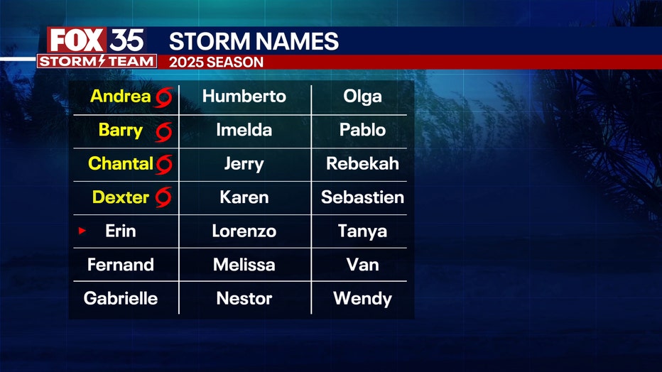
2025 Atlantic hurricane season
Big picture view:
The 2020 Atlantic hurricane season runs from June 1 through Nov. 30.
While the season lasts for six months, the most intense period is generally from mid-August to October. The peak in hurricane activity is linked to favorable atmospheric and ocean conditions like warm sea surface temperatures and specific wind patterns. Although the peak is in the later months, storms can form before and after the official season dates.
Forecasters are predicting an above-average hurricane season for 2025, with the potential for more named storms, hurricanes and major hurricanes compared to historical averages.

VIDEO: 2025 Atlantic hurricane forecast explained
FOX 35 Meteorologists Laurel Blanchard and Noah Bergren discuss Colorado State University's April hurricane forecast for the 2025 Atlantic hurricane season. Plus, a researcher with Colorado State University joins to discuss how this prediction it put together, and what factors are influencing this year's forecast.
The Source: This story was written based on information gathered by FOX 35 Storm Team Meteorologist Brooks Garner.