

Invest 93L: Tropical depression could form by end of week, bringing heavy rainfall across Gulf Coast

Tropics update: July 16, 2025
FOX 35 Storm Team Senior Meteorologist Noah Bergren has the latest conditions in the tropics. The 2025 Atlantic Hurricane Season runs June 1 - November 30. Download the FOX Local app for tropical alerts and notifications.
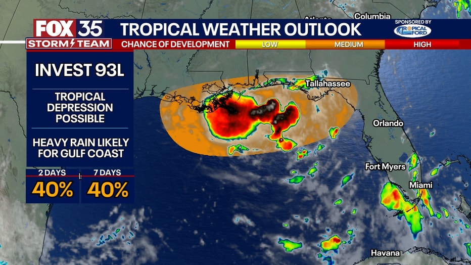
ORLANDO, Fla. - The National Hurricane Center (NHC) and the FOX 35 Storm Team are tracking an area of low pressure sitting near the panhandle of Florida: Invest 93L. With plenty of fuel to feed the disturbance, Invest 93L has the potential to become a tropical depression by the end of this week.
Here's the latest on what we know about the disturbance and how it could impact Florida.
What is Invest 93L?
What we know:
Invest 93L is an area of low pressure that's sitting near the panhandle of Florida. The NHC has increased the chances of tropical development to 40% in the next 48 hours and over the next seven days.
The disturbance has been on a westward track, but if it drifts further south and emerges or redevelops in the Gulf, it could show signs of steady development. The system would potentially be named "Dexter" if it develops.
CLICK TO DOWNLOAD THE FOX LOCAL APP
What could contribute to the system's development?
Dig deeper:
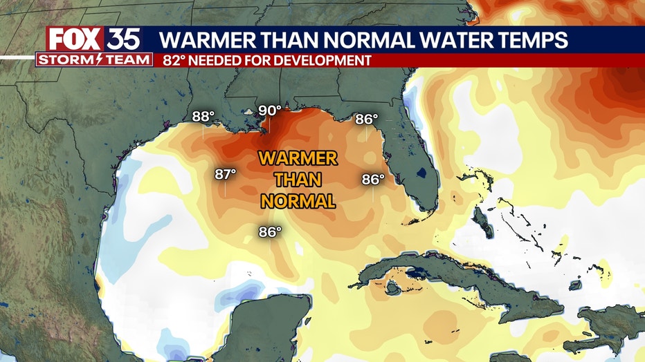
The waters in the Gulf are very warm, especially for this time of year, so the disturbance will have plenty of fuel to feed off of in the coming days. A tropical depression is possible by the end of this week.
What's next:
Hurricane Hunter aircraft are scheduled to survey the system Wednesday, once the center of circulation is over open water.
What impact will Invest 93L have on the U.S. and on Florida?
Big picture view:
Regardless of the development, heavy rainfall is likely across the Gulf Coast. The rain will be the heaviest in southern Louisiana, where several inches of rain are expected to fall. Already, Flash Flood Watches have been posted for parishes in Louisiana with 3-6 inches of rainfall expected through Friday. Severe weather such as waterspouts and tornadoes would also be a threat in the stronger cells.
Local perspective:
Heavy rainfall, lightning and some flooding are possible in Orlando and Central Florida as this system moves across the state.
Rainfall totals vary throughout the state. It all depends on where the rainbands fall and how fast they move, according to the FOX 35 Storm Team.
Some areas could receive an inch of rain or less, while others could see upwards of 5 inches of rain.
SIGN-UP FOR FOX 35'S BREAKING NEWS, DAILY NEWS NEWSLETTERS
Some spots west of Orlando, closer to the Gulf, could pick up between 4–5 inches, while areas in Volusia or Brevard County only see an inch or two.
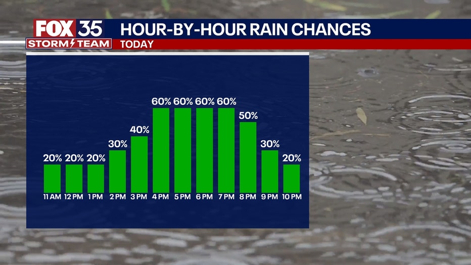
Looking at Wednesday's weather, a 60% chance of rain is anticipated, mainly in the afternoon hours. A few showers could sneak onshore in Brevard and Volusia counties between 9 a.m. and noon, with the best chances of rain taking place for the inland areas. The main timeline for the highest chances of rain will be from 3-9 p.m.
The Source: This story was written based on information shared by the National Hurricane Center (NHC), FOX Weather and the FOX 35 Storm Team on July 16, 2025.