

National Hurricane Center tracking 'triangle of tropical trouble' as Atlantic Basin bubbles with activity

Orlando Weather Forecast PM: August 21, 2025
FOX 35 Storm Team Senior Meteorologist Noah Bergren is tracking a recap of Thursday storms and many more coming Friday.
ORLANDO, Fla. - The National Hurricane Center (NHC) has its eyes on what appears to be a "triangle of tropical trouble" as the Atlantic Ocean begins to bubble up with activity ahead of the peak of hurricane season.
‘Triangle of tropical trouble’
Here's everything we know about the three systems, as well as the latest updates on Hurricane Erin.
Invest 90L
Forecasters with the NHC are currently tracking Invest 90L, which is located neer the Leeward Islands in the Tropical Atlantic.
An area of showers and thunderstorms associated with a tropical wave located a few hundred miles east of the Leeward Islands has changed little over the past several hours.
CLICK TO DOWNLOAD THE FOX LOCAL APP
Environmental conditions appear conducive for further development of this system, and a tropical depression is likely to form this weekend while it moves near or to the north of the northern Leeward Islands.
The system has a 60% chance of formation within the next 48 hours and a 80% chance of formation over the next week.

Invest 99L
The NHC is also watching Invest 99L, which is located in the Eastern Tropical Atlantic.
Showers and thunderstorms associated with a tropical wave located several hundred miles west-southwest of the Cabo Verde Islands show some signs of organization.
Environmental conditions appear marginally favorable for additional development over the next day or so while the system moves west-southwestward at around 15 mph, and a short-lived tropical depression could form.
In a couple of days, environmental conditions are expected to become unfavorable for further development.
The system has a 50% chance of formation within the next 48 hours and a 50% chance of formation over the next week.
Central Atlantic system
Lastly, weather experts are monitoring a system in the Central Atlantic.
The small area of low pressure located about 1200 miles southwest of the Azores is producing limited showers and thunderstorms.
Upper-level winds are only marginally conducive for development while the system moves slowly eastward over the next couple of days.
The system has a 20% chance of formation within the next 48 hours and a 20% chance of formation over the next week.
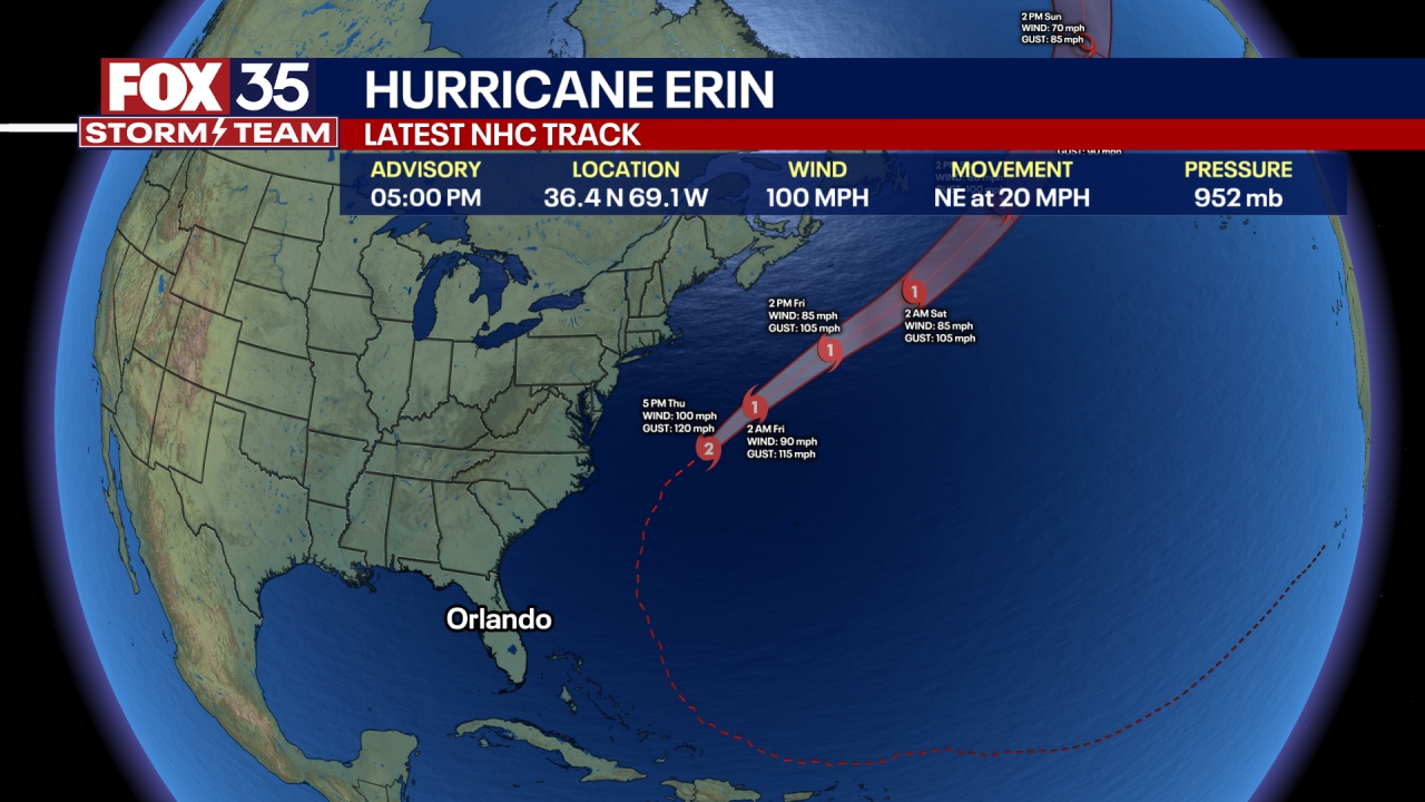
Hurricane Erin
Dig deeper:
Late Thursday evening, Hurricane Erin was located about 420 miles east-northeast of Cape Hatteras, North Carolina, and about 365 miles north-northwest of Bermuda.
The hurricane is moving toward the north-northeast, and a faster northeastward to east-northeastward motion is expected during the next couple of days. The center of the storm will move over the western Atlantic between the United States east coast and Bermuda through early Friday, and then pass south of Atlantic Canada on Friday and Saturday. Gradual weakening is forecast during the next couple of days, and the storm is expected to become post-tropical on Saturday.
SIGN-UP FOR FOX 35'S BREAKING NEWS, DAILY NEWS NEWSLETTERS
The Category 2 storm had maximum sustained winds of 100 mph and a minimum central pressure of 952 mb.
Despite Hurricane Erin not being forecast to make landfall in Florida, the state is still experiencing significant indirect impacts. Dangerous beach conditions brought on by the storm have the entire East Coast on high alert. Beaches along Florida's coastline, particularly in Northeast and East Central Florida, are experiencing frequent and life-threatening rip currents due to the large ocean swells generated by Erin.
The Source: This story was written based on information shared by the National Hurricane Center (NHC), FOX Weather and the FOX 35 Storm Team on Aug. 21, 2025.