

Orlando weather: Flash flooding as torrential rains loom; possible tropical storm development by weekend
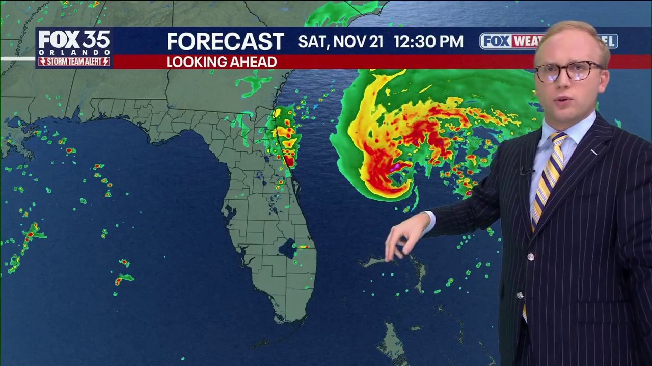
Orlando Weather Forecast: Major rain, flooding, Tropical Storm Kyle?
12-20" of rain, with localized totals to 24" possible for parts of central Florida in the coming few days. That and a tropical storm may form off the east coast. FOX 35 Storm Team Senior Meteorologist Noah Bergren is tracking the latest as of 6PM Wednesday.
ORLANDO, Fla. - Central Florida residents are bracing for a prolonged deluge as a potent weather system threatens to dump up to 20 inches of rain, raising the risk of severe flash flooding through Friday and potentially developing into a named tropical system off the coast by the weekend.
Multiple waves of heavy rain and gusty winds
Big picture view:
The heaviest impacts will begin tonight and continue through Thursday, with multiple rounds of intense rainfall and gusty winds on the way.
"Rain is going to continue to pick up, and we will see the first wave of rain between 9 p.m. Wednesday and 2 p.m. Thursday. That is significant," said Noah Bergren, a meteorologist with the FOX 35 Storm Team.
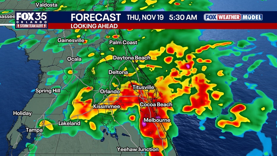
"This first round of big stuff will produce some flash flooding in Brevard, Osceola and Volusia counties overnight tonight into Thursday morning," Bergren added.
Officials have placed much of the region on high alert. According to forecast models, a second wave of heavy precipitation could quickly follow the initial deluge.
"Another band is possible Thursday night into Friday morning," Bergren said, noting that "these bands of rain could produce wind gusts up to 50 miles an hour."
Rain forecast: How much could fall in Central Florida?
By the numbers:
The volume of anticipated rainfall has prompted serious concern for widespread flooding.
The FOX 35 Storm Team estimates that the highest rain totals will be concentrated in Brevard, eastern Osceola, eastern Orange, and southern Volusia counties, where 12 to 20 inches of rain is expected, with locally higher amounts possible.
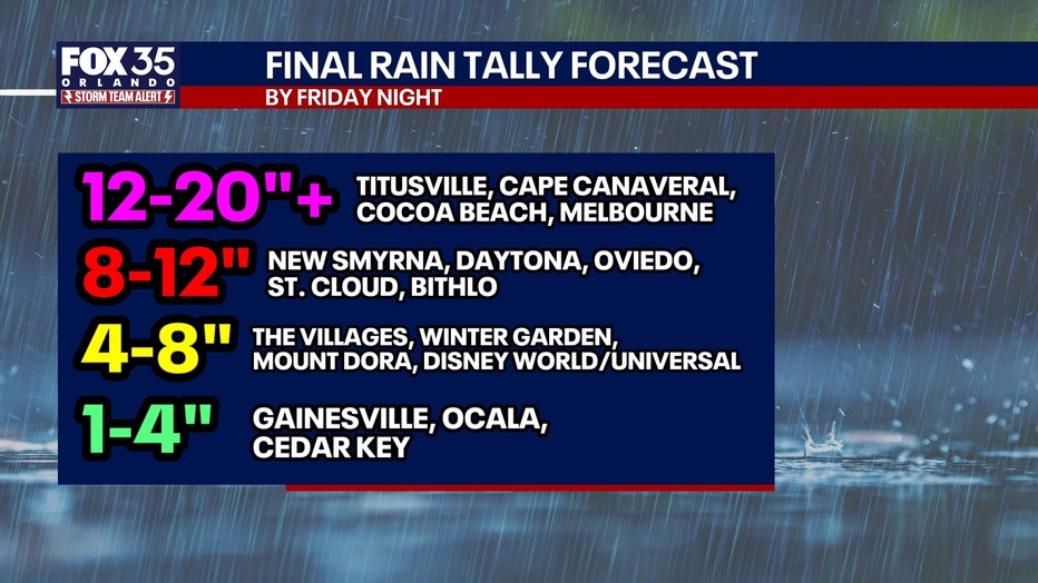
In coastal areas like Titusville, Cape Canaveral, Cocoa Beach, and Melbourne, forecast totals are expected to exceed the 12-to-20-inch mark.
Meanwhile, inland areas including Daytona, Oviedo, and St. Cloud could see between 8 and 12 inches, with the Disney World and Universal Orlando resort areas expecting 4 to 8 inches. Even areas further west, such as Gainesville and Ocala, are forecast to receive 1 to 4 inches.
MAP: Flood watch issued for most of Central Florida
Why you should care:
A flood watch is in effect from Tuesday afternoon through Friday for several Central Florida counties, including Brevard, Indian River, Orange, Osceola, Seminole, and Volusia.
Flash flooding is likely in many areas of Brevard, Volusia, and Flagler counties. Rapid water rises could creep into neighborhoods and homes over the next three days.
Our biggest concern is the rapid amount of water that could fall.
Flash flood threat peaks Thursday
The flood risk is expected to remain critical through Friday, particularly in low-lying and poorly drained areas. "In terms of the flash flood risk, that is going to be tonight through Friday with the worst weather expected Thursday," Bergren said.
Potential weekend development into Tropical Storm Kyle
Tracking the Tropics:
As the heavy rain event begins to subside over the Florida peninsula, the focus will shift to the Atlantic. Environmental conditions, fueled by warm ocean temperatures of up to 82 degrees off the Florida coast, could allow the system to organize.
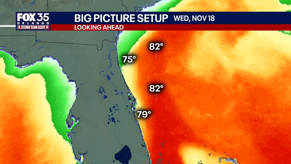
"As this entire area of rain and energy pulls away, it could form into a tropical or subtropical storm Saturday off the East Coast of Florida," Bergren said. "If it does, it would be named Kyle."
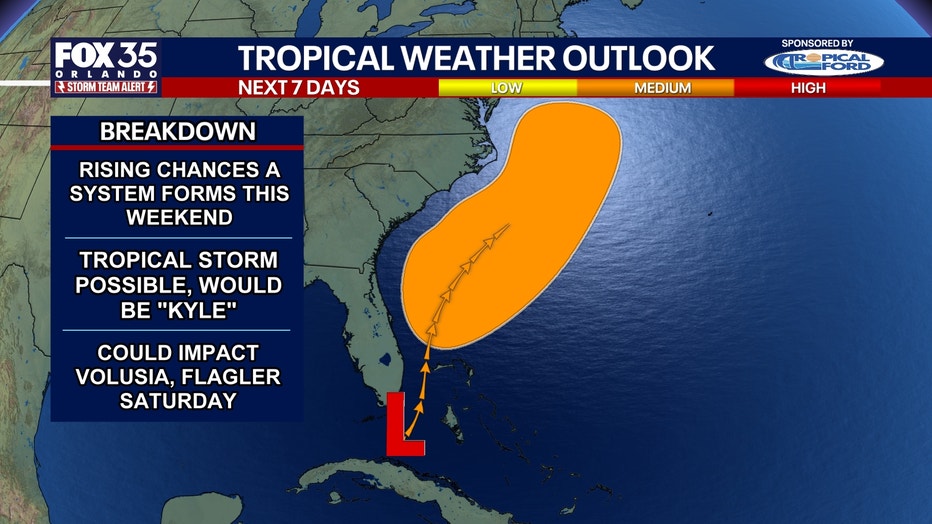
Residents along the coast are advised to monitor the system closely, as its track will determine the severity of weekend coastal impacts.
"Depending on how close to the East Coast of Florida it forms, it could impact directly our East Coast counties with some outer bands, gusty winds, rough surf, and beach erosion Saturday into Sunday," Bergren said.
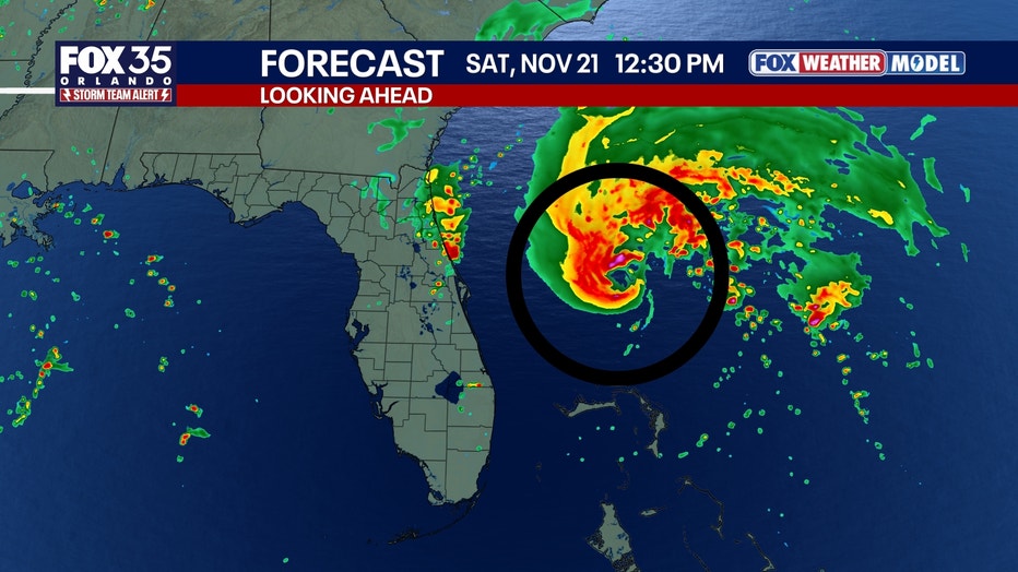
The storm system's development comes during the later weeks of the hurricane season. Local emergency management officials are urging residents to avoid driving through flooded roadways, secure loose outdoor items, and stay tuned to local weather updates.
The Source: This story uses information from the FOX 35 Storm Team.