

Tropical Storm Nicole: Hurricane Warning issued for portions of Florida's east coast
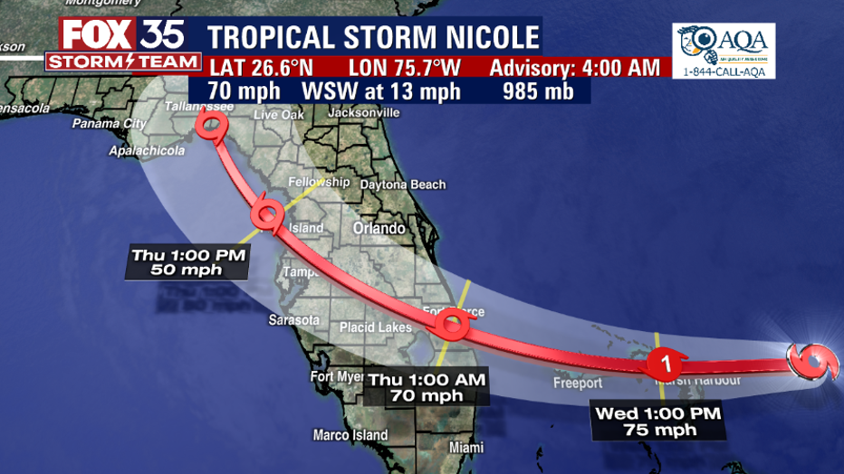
ORLANDO, Fla. - Nicole is expected to become a hurricane on Wednesday as the storm continues to move toward Florida.
As of Wednesday morning, maximum sustained winds were measured at 70 mph, bringing it close to Category 1 hurricane.
Nicole will approach the northwestern Bahamas Wednesday, move near or over those islands by midday, and approach the east coast of Florida within the hurricane warning area tonight. Nicole's center is then expected to move across central and northern Florida into southern Georgia Thursday and Thursday night, and then across the Carolinas Friday and Friday night.
"Nicole is forecast to become a hurricane near the northwestern Bahamas and remain a hurricane when it reaches the east coast of Florida tonight," the National Hurricane Center said. "Nicole is expected to weaken while moving across Florida and the southeastern United States Thursday through Friday, and it is likely to become a post-tropical cyclone by Friday night over the Mid-Atlantic states."
Tropical Storm Nicole: The latest Florida arrival timeline
Tropical Storm Warnings have been expanded and there are several Hurricane Watches and Warnings that have been issued for Florida as Nicole targets the state.
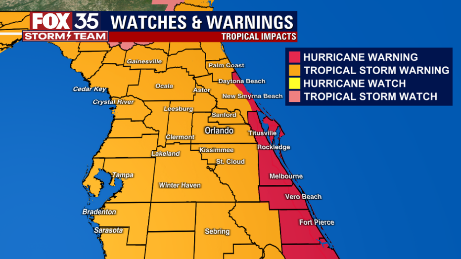
WARNINGS AND WATCHES
A Hurricane Warning is in effect for:
- The Abacos, Berry Islands, Bimini, and Grand Bahama Island in the northwestern Bahamas
- Boca Raton to Flagler/Volusia County Line Florida
A Tropical Storm Warning is in effect for:
- Bimini in the northwestern Bahamas
- Hallandale Beach Florida to Boca Raton Florida
- Flagler/Volusia County Line Florida to South Santee River South Carolina
- North of Bonita Beach to Indian Pass Florida
- Lake Okeechobee
A Hurricane Watch is in effect for:
- Hallandale Beach to Boca Raton Florida
- Lake Okeechobee
A Storm Surge Warning is in effect for:
- North Palm Beach Florida to Altamaha Sound Georgia
- Mouth of the St. Johns River to Georgetown Florida
- Anclote River Florida to Ochlockonee River Florida
A Storm Surge Watch is in effect for:
- Ochlockonee River to Indian Pass Florida
- South of North Palm Beach to Hallandale Beach Florida
- Altamaha Sound Georgia to South Santee River South Carolina
A Tropical Storm Watch is in effect for:
- South of Hallandale Beach to north of Ocean Reef Florida
Winds guests could get up to 85 mph along Florida's east coast. Tropical storm conditions are also occurring along portions of the east coast of Florida and will spread northward within the warning area through Georgia and South Carolina today and tonight. Hurricane conditions are expected within the hurricane warning area in Florida tonight or Thursday morning. Hurricane conditions are possible within the hurricane watch area tonight. Tropical storm conditions are expected within the warning area along the west coast of Florida by this evening or tonight.
The combination of a dangerous storm surge and the tide will cause normally dry areas near the coast to be flooded by rising waters moving inland from the shoreline. Central and northern portions of the Florida Peninsula could get up to 3 to 5 inches and even 8 inches in some areas. A few tornadoes are possible this evening through Thursday across eastern Florida, southeastern Georgia, and southern South Carolina.
The FOX 35 Storm Team says you should have your hurricane preps done by Wednesday, no later than 3 p.m. as weather conditions are expected to deteriorate. Power outages are possible.