

Tropical Storm Erin tracker: Hurricane forecast, timeline, spaghetti models, Florida impact

Tropical Update: August 14PM, 2025
FOX 35 Storm Team Senior Meteorologist Noah Bergren is tracking Erin set to become a large and powerful hurricane in the Atlantic.
ORLANDO, Fla. - Tropical Storm Erin is continuing its steady westward march across the Atlantic, gaining strength and expected to reach hurricane status by Friday, according to the National Hurricane Center (NHC).
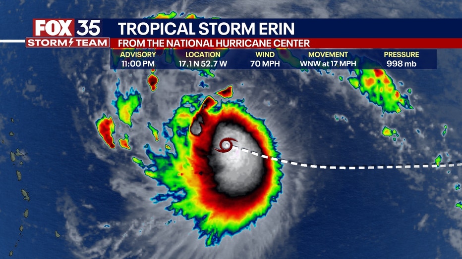
As of 11 p.m. on Thursday, Erin was approximately 690 miles east of the northern Leeward Islands. The storm is currently moving west at 17 mph with maximum sustained winds of 70 mph.
Tropical Storm Erin to become major hurricane
What we know:
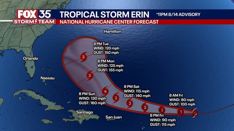
Forecasters predict that Erin will continue on a westward track today, shifting slightly to the west-northwest by tonight and into the weekend. This path is expected to bring the storm near or just north of the northern Leeward Islands sometime over the weekend.
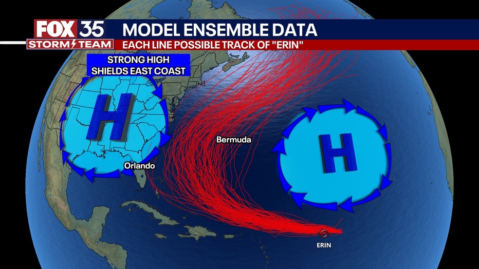
A few more models are bringing Erin further west before the forecast curve, possibly kicking the Carolina coast. However, the FOX 35 Storm Team says it's way too early to tell. As the storm gets stronger and possibly makes the predicted curve, we will know more about exactly what will happen.
The NHC anticipates gradual strengthening over the next 24 hours, with the storm likely to intensify more significantly by Friday, potentially becoming the first hurricane of the 2025 Atlantic season. The warmer ocean water is assisting in the storm's rapid strengthening.
SIGN-UP FOR FOX 35'S BREAKING NEWS, DAILY NEWS NEWSLETTERS
Tropical Storm Erin Forecast track
"Swells generated by Erin will begin affecting portions of the northern Leeward Islands, the Virgin Islands and Puerto Rico by this weekend," the NHC said. "These swells are likely to cause life-threatening surf and rip current conditions. Please consult products from your local weather forecast office."
Spaghetti models
Will it impact Florida?
What we know:
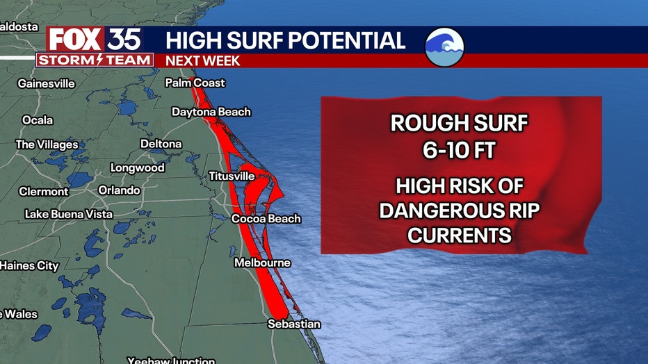
Even if Erin remains offshore, forecasters warn that dangerous rip currents and high surf are expected along Florida’s coast as the storm approaches the western Atlantic.
Florida's east coast will experience rough surf arriving as early as Monday.
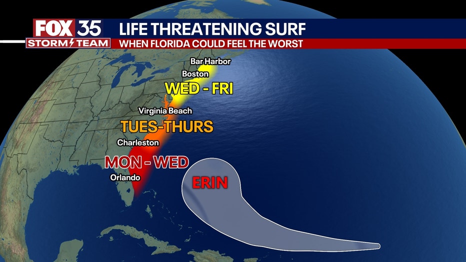
There is a high risk of dangerous rip currents with wave heights reaching between 6 and 10 feet.
Invest 98L brews in the Gulf
What we know:
The NHC is also monitoring a broad area of low pressure near the west coast of the Bay of Campeche, which is currently producing disorganized showers and thunderstorms.
According to the latest outlook, the disturbance is expected in the southwestern Gulf during the next day or two, where environmental conditions are marginally conducive for further development.
CLICK TO DOWNLOAD THE FOX LOCAL APP
The system is expected to move inland over northeastern Mexico or southern Texas by late Friday, reducing the chance of tropical cyclone formation. However, heavy rainfall is still possible in those areas over the next few days.
Forecasters give the system a 40% chance of formation over both the next 48 hours and the next seven days.
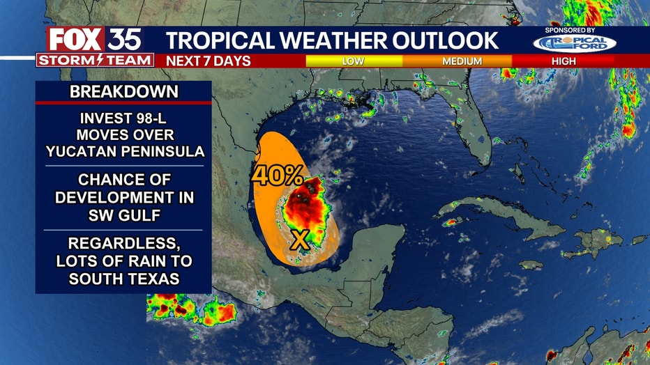
An Air Force Reserve Hurricane Hunter is currently on its way to investigate the system.
Looking Ahead:
The FOX 35 Storm Team is monitoring another wave that is making its way off the coast of Africa, so this will be our next system to watch carefully after Erin. The next few storm names include Fernand, Gabrielle, Humberto and Imelda.
The Source: This story was written based on information shared by the National Hurricane Center (NHC) and the FOX 35 Storm Team on Aug. 14, 2025.