

'Gulf effect' snow in Florida: Flurries possible this weekend. Where, when and how much?
Orlando Weather Forecast: Extreme Florida Cold
FOX 35 Meteorologist Noah Bergren is tracking extreme cold temperatures over the weekend. Also the chance of flurries in Florida.
ORLANDO, Fla. - A cold front is forecast to arrive on Saturday, bringing scattered rain showers during the morning and midday hours.
Winds will increase significantly Saturday afternoon through the overnight period, with gusts ranging from 30 to more than 40 mph.
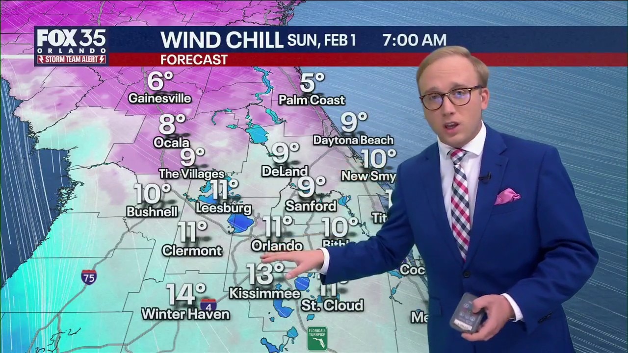
When will coldest temperatures arrive in Orlando?
Timeline:
The coldest wind chills are expected Sunday morning, dropping into the single digits and teens.
CLICK TO DOWNLOAD THE FOX LOCAL APP
While winds will ease Sunday afternoon and evening, the calmer conditions will allow air temperatures to fall even lower by Monday morning. The coldest temperatures are expected early Monday, while the most dangerous wind chills will occur Sunday morning.


FOX 35 Storm Team Alerts are in effect Sunday and Monday for potentially record-breaking cold. Temperatures could fall into the low to mid-20s, with wind chills in the teens or lower.


This is expected to be the coldest weather experienced in Orlando and Central Florida since 2010.
Could it snow in Florida and where?
What To Expect:
Two areas of Florida could see rare snow flurries this weekend as a strong low-pressure system develops northeast of the state.
Zones that could see flurries
The first chance is Saturday evening into overnight hours, when a few flurries could reach Jacksonville or possibly Flagler County.
SIGN-UP FOR FOX 35'S BREAKING NEWS, DAILY NEWS NEWSLETTERS
Sunday morning brings a more unusual possibility: "Gulf Effect" snow flurries, a phenomenon similar to lake-effect snow seen in the Great Lakes and Upstate New York.

What is Gulf effect snow?
Gulf-effect snow occurs when much colder air moves over the relatively warm waters of the Gulf. That temperature contrast allows warm, moist air to rise and, under just the right conditions, produce narrow bands of snow.
A frigid Arctic air mass moving over the still-warm Gulf, where water temperatures are in the 60s, can create instability in the atmosphere. Clouds and showers form, and in rare cases, the precipitation can fall as snow instead of rain.

While Gulf effect snow is extremely rare and requires precise meteorological conditions, forecasters say it is possible from Saturday night into Sunday morning. Areas including the Tampa region and western-central Florida could see a few flakes if conditions align.

Officials say more specific forecasts will be available Friday as updated model data becomes available.
The Source: This story was written based on information shared by the National Weather Service and the FOX 35 Storm Team.