

Florida faces rising heat, soaking rains as summer kicks off
FLORIDA - The long-anticipated three-month summer outlook was released this week by federal forecasters from the National Oceanic and Atmospheric Administration (NOAA) Climate Prediction Center, and let's just say it’s about to get wetter and even warmer.
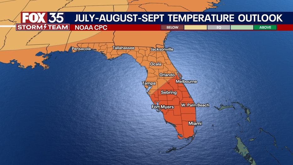
Florida is staring down a higher-than-normal chance of both above-average temperatures and above-average rainfall through July, August and September, which means more heat and rain are coming at the same time.
How could we be in a drought with all the recent rain?
Local perspective:
As of June 19, nearly all of peninsular Florida is in some level of drought, except for the Orlando metro. The Panhandle region is also no longer in drought.
The recent rains have helped a lot, but there's still much more to be done for most of our state.
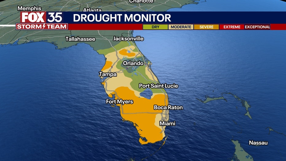
(Credit: FOX 35 Storm Team)
From the citrus groves of Polk County to the wetlands of Broward, soil moisture has been falling behind — fast. News of a rainy summer may interrupt pool and beach plans, but it isn't all bad.
However, we are about to enter a pretty dry next week as the summer's first heat wave overtakes the eastern third of the U.S.
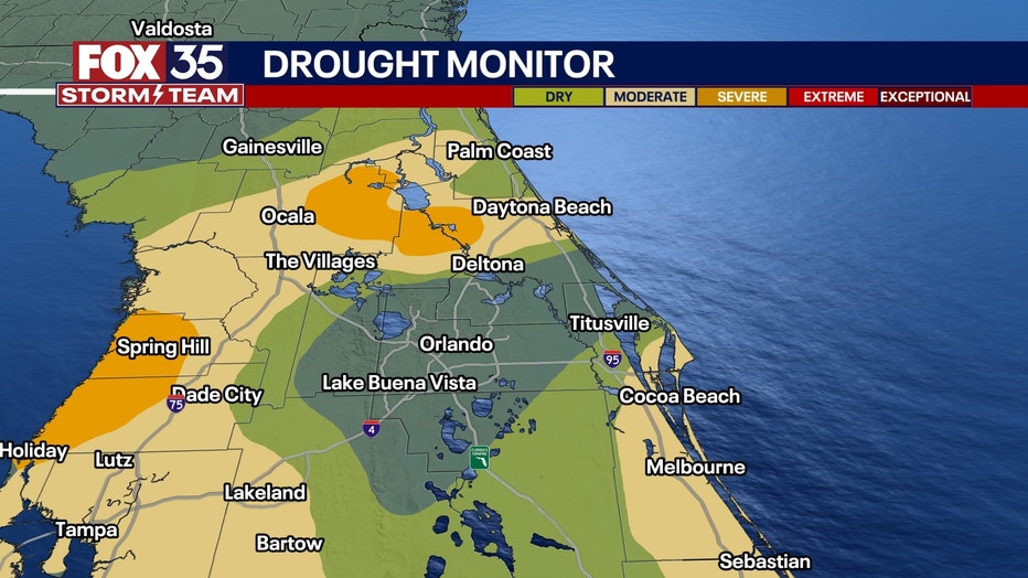
(Credit: FOX 35 Storm Team)
Does the ‘above-normal rain’ mean tropical trouble?
Dig deeper:
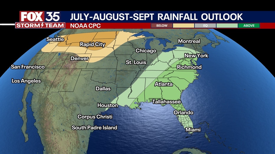
The higher-than-normal chance of above-average rainfall could possibly lead to trouble in the tropics.
Although NOAA doesn’t make hurricane-specific forecasts in the graphic below, the above-normal precipitation forecast for Florida during the heart of hurricane season is definitely consistent with an active tropical pattern.
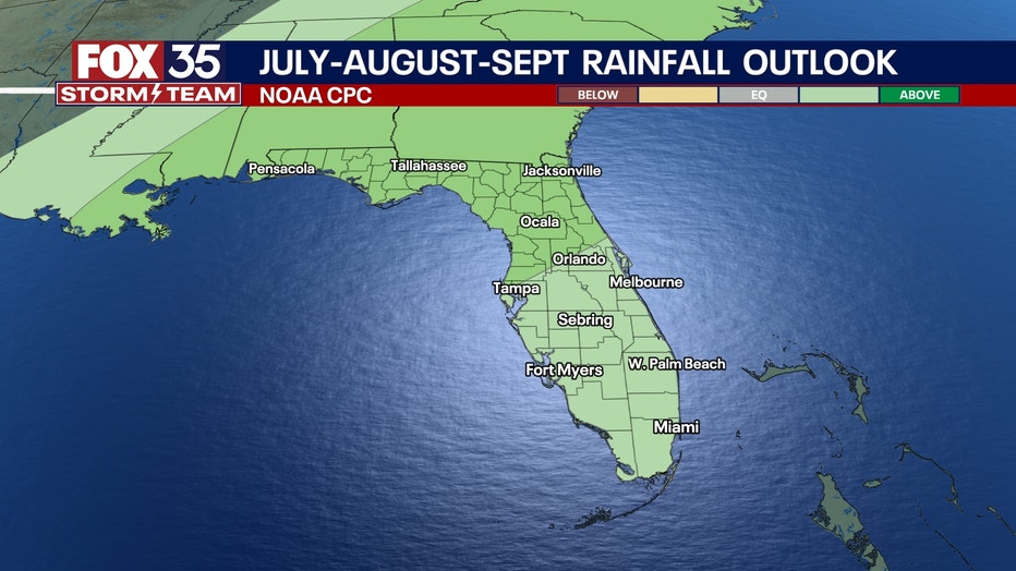
(Credit: National Oceanic and Atmospheric Administration)
Whether it's tropical storms or hurricanes, those downpours could be part of the reason rain chances are running higher. And with drought-parched ground, initial rains might run off rather than soak in, potentially boosting flash flooding risks. Then again, a few well-timed tropical systems — minus the damaging winds — could also help alleviate drought conditions across the state.
In short, while the storm risk is real, there’s also an opportunity for drought recovery — if the rain comes in manageable waves.
What about the rest of the country?
Big picture view:
Nationwide, this summer is shaping up to be hot and dry in all the usual places — and then some.
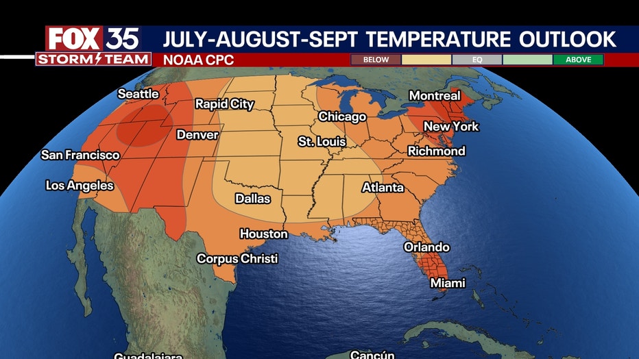
(Credit: National Oceanic and Atmospheric Administration)
Above-normal temperatures are expected across much of the west, Southwest and Northeast, with a particularly high probability centered on the Intermountain West and Four Corners region, as well as New England.
Meanwhile, the Upper Midwest and Plains will likely face a dryer-than-average season, which has big implications for corn and soybean crops — especially if early drought signals persist or expand.
And don’t forget the cities. With New York City, Boston and D.C. in line for above-average heat, expect urban heat risk and energy demand to spike.
In places where air-conditioning access is limited, public health could be on the line — especially during multi-day heat waves.
(Credit: National Oceanic and Atmospheric Administration)
Can I try and plan my day around this outlook?
What you can do:
Seasonal outlooks show general trends, not specific forecasts. They don’t tell us what will happen on any given day, whether highs or lows are driving the trend of temperatures being "above-normal" in this case, or give exact probabilities of it being warmer or cooler for your location. They also don’t predict specific temperatures (highs or low), rainfall amounts, or even whether it’ll be rain or snow.
Rest assured, if we get snow in Florida this summer, there are bigger problems!
(Credit: National Oceanic and Atmospheric Administration)
Bottom line for Florida?
What To Expect:
Florida’s summer forecast is hot, humid and stormy, but also hopeful for beneficial rain (in the context of drought.) While the drought is real, so is the potential for a rebound. Just keep an eye on the tropics.
We'll likely have higher energy bills with air conditioning working harder, but potentially lower water bills with less irrigation needed.
As we say around here: When it rains, it really pours.
FOX 35 Storm Tracker Radar and Live Weather Cameras
Track live when storms move across your area using the FOX 35 Storm Tracker Radar below. You can also watch as heavy rain moves across Central Florida on our Live Weather Cameras' page here.

More radar maps from FOX 35 Storm Tracker Radar
- Brevard County
- Flagler County
- Lake County
- Marion County
- Osceola County
- Orange County
- Polk County
- Seminole County
- Sumter County
- Volusia County
- U.S./National Radar
STAY CONNECTED WITH FOX 35 ORLANDO:
- Download the FOX Local app for breaking news alerts, the latest news headlines
- Download the FOX 35 Storm Team Weather app for weather alerts & radar
- Sign up for FOX 35's daily newsletter for the latest morning headlines
- FOX Local: Stream FOX 35 newscasts, FOX 35 News+, Central Florida Eats on your smart TV
The Source: This story was written based on information shared by FOX 35 Storm Team Meteorologist Brooks Garner and gathered from the National Oceanic and Atmospheric Administration (NOAA).