

Florida summer heatwave: No heat advisories so far this year. Here's why.
FLORIDA - While Florida is no stranger to summer swelter, 2025 has been pretty quiet in one key way: the National Weather Service (NWS) in Melbourne has issued zero heat advisories this year — a dramatic contrast to the previous two summers when they started rolling in as early as May.
This absence is especially striking, considering temperatures have consistently run above normal, raising the question: Why haven’t we hit advisory criteria?
What is a heat advisory?
When the heat index or "feels like temperature" reaches 108°F, the NWS issues a heat advisory to reflect the danger to people who may be operating in this swelter.
At this temperature, it takes a lot longer for the body to cool itself, and that can lead to hyperthermia with symptoms of heat exhaustion and heat stroke.
How common are heat advisories?
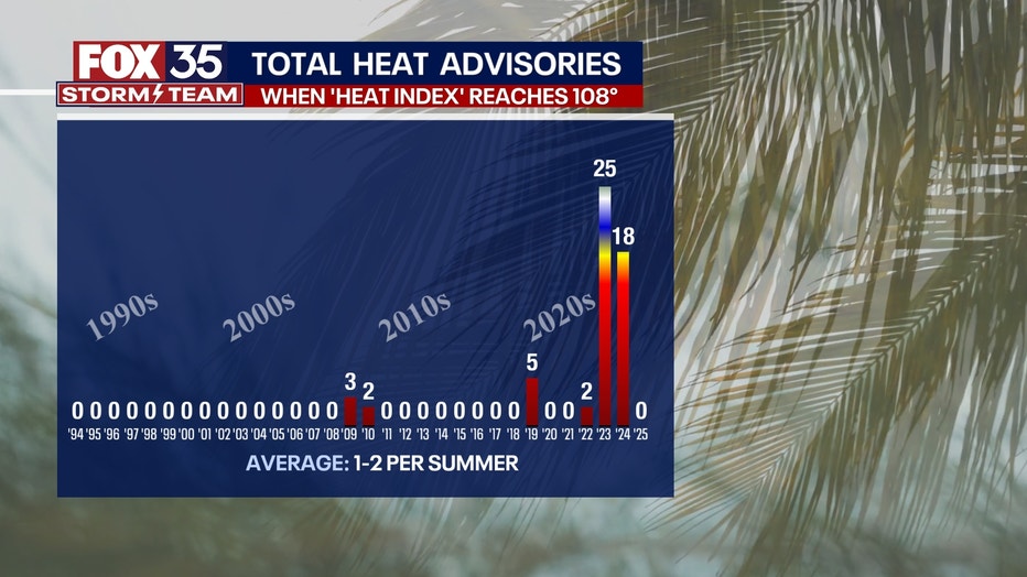
By the numbers:
Here's a look at the heat advisory issues issued locally in the last few years:
- 2025 so far has had ZERO heat advisories, despite our temperatures reaching regularly warmer-than-normal levels.
- 2024 had 18 separate heat advisories. The first was issued May 18, and the last was issued Sept. 29.
- 2023 set a bit of a record by a staggering distance, with 25 ADVISORIES! Examining the last 21 years of data, our region typically only sees one to two heat advisory days per summer. In 2023, the first advisory was issued a bit later in the season, on July 4, and peaked in August with regular, almost daily heat advisories issued until the end of that month.
Why have there been fewer heat alerts in 2025?
Dig deeper:
The drought may be to blame — or rather, to thank.
This year, much of Central Florida has been locked in a severe to extreme drought, the worst since 2017. Drought conditions are improving with recent rains, but dry grounds typically lead to lower dew points, reducing the heat index. So, while the air temperature may be high (or even higher), it may not "feel" hot enough by heat index standards to meet official thresholds due to the lower humidity.
Climate factors at play
The story doesn’t end with the drought. Sea surface temperatures (SSTs) — particularly around Florida and the Gulf — have been cooler in 2025 compared to the previous two summers.
In both 2023 and 2024, anomalously warm waters increased atmospheric moisture, boosting dew points and pushing apparent temperatures into the danger zone. With less oceanic moisture to draw from this year, humidity is down, and so are heat index values.
The Tonga Volcano Hypothesis
Some researchers point to another possible contributor to the 2023 and 2024 spikes: the 2022 Hunga Tonga-Hunga Ha’apai volcanic eruption, which blasted an estimated 50 million tons of water vapor into the stratosphere.
According to the National Oceanic and Atmospheric Administration (NOAA), this rare injection of moisture may have globally amplified humidity levels, particularly over tropical and subtropical regions, including Florida — potentially helping explain the 25 advisories in 2023 and 18 in 2024, despite 2025’s total still standing at zero.
This certainly remains the subject of research.
El Niño, La Niña and seasonal drivers
ENSO phases may also be a factor.
A strong El Niño pattern was present during much of 2023 and early 2024, which often leads to a warmer, more humid spring and summer for Florida. Now, as La Niña conditions begin to develop, drier and more stable air patterns could continue to suppress the moisture needed for dangerous heat index values, further delaying or preventing advisories this year.
Are the hottest days still ahead?
What's next:
Historically, August is Florida’s hottest month, with high heat and maximum humidity working together.
- In 2023, 12 of the 25 advisories came in August.
- 2024 saw seven heat advisories in August — even as totals for that year were lower overall.
This raises the inevitability that 2025’s quiet summer will NO DOUBT heat up, especially as late-season intense humidity makes its annual comeback.
But for now, the combination of drier soils, slightly cooler ocean temperatures and regional drought appear to be factors in keeping the advisory count at zero.
FOX 35 Storm Tracker Radar and Live Weather Cameras
Track live when storms move across your area using the FOX 35 Storm Tracker Radar below. You can also watch as heavy rain moves across Central Florida on our Live Weather Cameras' page here.

More radar maps from FOX 35 Storm Tracker Radar
- Brevard County
- Flagler County
- Lake County
- Marion County
- Osceola County
- Orange County
- Polk County
- Seminole County
- Sumter County
- Volusia County
- U.S./National Radar
STAY CONNECTED WITH FOX 35 ORLANDO:
- Download the FOX 35 News app for breaking news alerts, the latest news headlines
- Download the FOX 35 Storm Team Weather app for weather alerts & radar
- Sign up for FOX 35's daily newsletter for the latest morning headlines
- FOX Local: Stream FOX 35 newscasts, FOX 35 News+, Central Florida Eats on your smart TV
The Source: This story was written based on information shared by FOX 35 Storm Team Meteorologist Brooks Garner and gathered from the National Weather Service (NWS) in Melbourne and the National Oceanic and Atmospheric Administration (NOAA).